
RI_542
Type of resources
Topics
Keywords
Contact for the resource
Provided by
Years
Formats
Representation types
Update frequencies
status
-
Since 1988, the governments of Canada and Quebec have been working together to conserve, restore, protect and develop the St. Lawrence River under the St. Lawrence Action Plan (SLAP). One of the projects identified under the theme of biodiversity conservation is the development of an integrated plan for the conservation of the natural environments and biodiversity of the St. Lawrence River. The identification of priority sites for conservation has been the first step of this planning exercise. Conservation planning of natural environments requires a reliable, accurate and up-to-date image of the spatial distribution of ecosystems in the study area. In order to produce an Atlas of Priority Sites for Conservation in the St. Lawrence Lowlands, an updated cartography of the land cover of this vast territory was undertaken. This project required obtaining reliable information on the natural environments of the St. Lawrence Lowlands. Although several land cover mapping projects have been conducted for specific types of habitats, it was particularly important to obtain a homogeneous product that would cover the entire territory and that would provide the most detailed information on its various thematic components: agricultural, aquatic, human-modified and forest environments, wetlands as well as old fields and bare ground. The methodology used to produce the land cover mapping of the St. Lawrence Lowlands thus relied mainly on combining and enhancing the best existing products for each theme. This project was made in collaboration with MDDELCC as part of the St. Lawrence Action Plan (SLAP). This dataset includes land cover polygons within a 10 km radius of the Centre-du-Québec administrative region within the St. Lawrence Lowlands.
-
Attribute data table which contains survey effort values for each season, total bird density, species richness value, species at risk score, and grid cell importance score.
-
Survey points is a point feature class containing transects and observations completed in 2011.
-
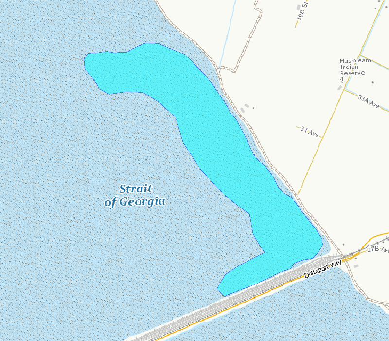
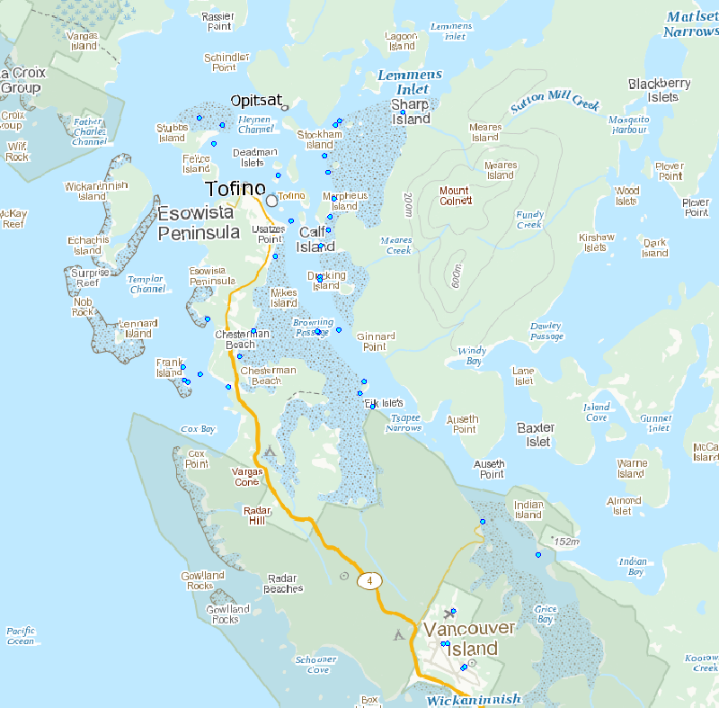
This polygon outlines the basic area included in the survey counts. This area is the best approximation of the mudflat that can be surveyed from shore and is exposed at tide tide height of 3.5 m, based on tidal predictions at Point Atkinson, British Columbia.
-
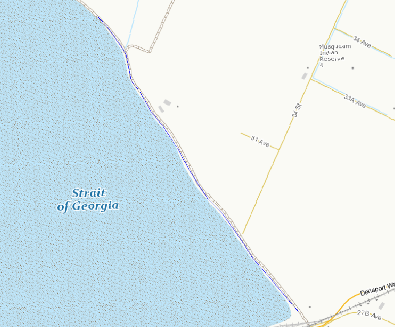
This line outlines the basic survey route included in the survey counts. This route is the best access to areas that can be surveyed from shore.
-
Since 1988, the governments of Canada and Quebec have been working together to conserve, restore, protect and develop the St. Lawrence River under the St. Lawrence Action Plan (SLAP). One of the projects identified under the theme of biodiversity conservation is the development of an integrated plan for the conservation of the natural environments and biodiversity of the St. Lawrence River. The identification of priority sites for conservation has been the first step of this planning exercise. Conservation planning of natural environments requires a reliable, accurate and up-to-date image of the spatial distribution of ecosystems in the study area. In order to produce an Atlas of Priority Sites for Conservation in the St. Lawrence Lowlands, an updated cartography of the land cover of this vast territory was undertaken. This project required obtaining reliable information on the natural environments of the St. Lawrence Lowlands. Although several land cover mapping projects have been conducted for specific types of habitats, it was particularly important to obtain a homogeneous product that would cover the entire territory and that would provide the most detailed information on its various thematic components: agricultural, aquatic, human-modified and forest environments, wetlands as well as old fields and bare ground. The methodology used to produce the land cover mapping of the St. Lawrence Lowlands thus relied mainly on combining and enhancing the best existing products for each theme. This project was made in collaboration with MDDELCC as part of the St. Lawrence Action Plan (SLAP). This dataset includes land cover polygons within a 10 km radius of the Laurentides administrative region within the St. Lawrence Lowlands.
-
Since 1988, the governments of Canada and Quebec have been working together to conserve, restore, protect and develop the St. Lawrence River under the St. Lawrence Action Plan (SLAP). One of the projects identified under the theme of biodiversity conservation is the development of an integrated plan for the conservation of the natural environments and biodiversity of the St. Lawrence River. The identification of priority sites for conservation has been the first step of this planning exercise. Conservation planning of natural environments requires a reliable, accurate and up-to-date image of the spatial distribution of ecosystems in the study area. In order to produce an Atlas of Priority Sites for Conservation in the St. Lawrence Lowlands, an updated cartography of the land cover of this vast territory was undertaken. This project required obtaining reliable information on the natural environments of the St. Lawrence Lowlands. Although several land cover mapping projects have been conducted for specific types of habitats, it was particularly important to obtain a homogeneous product that would cover the entire territory and that would provide the most detailed information on its various thematic components: agricultural, aquatic, human-modified and forest environments, wetlands as well as old fields and bare ground. The methodology used to produce the land cover mapping of the St. Lawrence Lowlands thus relied mainly on combining and enhancing the best existing products for each theme. This project was made in collaboration with MDDELCC as part of the St. Lawrence Action Plan (SLAP).
-
Observations on various types of wetlands, terrestrial environments, and vascular plants for 102 sites visited in 2012 and located on Lake Saint-Pierre are included in this dataset. Since the 1970s, Environment and Climate change Canada (ECCC) has been monitoring changes in wetlands under the State of the St. Lawrence River Monitoring program of the St. Lawrence Action Plan.
-
The rationale for developing this product was the recognized need for a standard and adaptable marine grid that could be used for planning or analysis purposes across projects. This nested grid has five spatial resolutions: 8km, 4km, 2km, 1km, and 500m. It covers the extent of the EEZ on the Canadian Pacific coast, and further east in order to encompass the Fraser River Delta and Puget Sound to account for ecological importance. There is a step-by-step methods document that gives users information on how to recreate the grid with ArcMap.
-
Since 1988, the governments of Canada and Quebec have been working together to conserve, restore, protect and develop the St. Lawrence River under the St. Lawrence Action Plan (SLAP). One of the projects identified under the theme of biodiversity conservation is the development of an integrated plan for the conservation of the natural environments and biodiversity of the St. Lawrence River. The identification of priority sites for conservation has been the first step of this planning exercise. Conservation planning of natural environments requires a reliable, accurate and up-to-date image of the spatial distribution of ecosystems in the study area. In order to produce an Atlas of Priority Sites for Conservation in the St. Lawrence Lowlands, an updated cartography of the land cover of this vast territory was undertaken. This project required obtaining reliable information on the natural environments of the St. Lawrence Lowlands. Although several land cover mapping projects have been conducted for specific types of habitats, it was particularly important to obtain a homogeneous product that would cover the entire territory and that would provide the most detailed information on its various thematic components: agricultural, aquatic, human-modified and forest environments, wetlands as well as old fields and bare ground. The methodology used to produce the land cover mapping of the St. Lawrence Lowlands thus relied mainly on combining and enhancing the best existing products for each theme. This project was made in collaboration with MDDELCC as part of the St. Lawrence Action Plan (SLAP). This dataset includes land cover polygons within a 10 km radius of the Lanaudière administrative region within the St. Lawrence Lowlands.