
2016
Type of resources
Topics
Keywords
Contact for the resource
Provided by
Years
Formats
Representation types
Update frequencies
status
-
Observations on various types of wetlands, terrestrial environments, and vascular plants for 102 sites visited in 2012 and located on Lake Saint-Pierre are included in this dataset. Since the 1970s, Environment and Climate change Canada (ECCC) has been monitoring changes in wetlands under the State of the St. Lawrence River Monitoring program of the St. Lawrence Action Plan.
-
The atlas provides printable maps, Web Services and downloadable data files representing seabirds at-sea densities in eastern Canada. The information provided on the open data web site can be used to identify areas where seabirds at sea are found in eastern Canada. However, low survey effort or high variation in some areas introduces uncertainty in the density estimates provided. The data and maps found on the open data web site should therefore be interpreted with an understanding of this uncertainty. Data were collected using ships of opportunity surveys and therefore spatial and seasonal coverage varies considerably. Densities are computed using distance sampling to adjust for variation in detection rates among observers and survey conditions. Depending on conditions, seabirds can be difficult to identify to species level. Therefore, densities at higher taxonomic levels are provided. more details in the document: Atlas_SeabirdsAtSea-OiseauxMarinsEnMer.pdf. By clicking on "View on Map" you will visualize a example of the density measured for all species combined from April to July - 2006-2020. ESRI REST or WMS map services can be added to your web maps or opened directly in your desktop mapping applications. These are alternatives to downloading and provide densities for all taxonomical groups and species as well as survey effort.
-
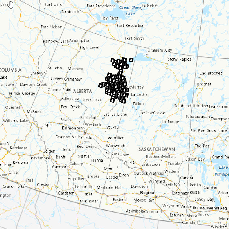
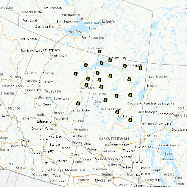
As part of a three year study funded by Environment and Climate Change Canada and Natural Resources Canada (ecoENERGY Innovation Initiative, project UOSGQ963; http://www.nrcan.gc.ca/energy/funding/current-fundingprograms/eii/4985) data were gathered to assess and monitor water quality conditions in northeastern British Columbia (BC). Defined in this datasetas portions of the Petitot, Fort Nelson, and Hay River basins, northeast BC is a region subject to both historical conventional oil and gas development and more recent unconventional oil and gas (UOG) development. UOG development in this area is presently focused on the Horn River Basin, Cordova Embayment and Liard Basin shale formations (BCOGC 2010, 2013a). Otherwise, UOG development in BC is centered in the Montney Play, located further south (Adams et al. 2016). Surface water quality assessment and monitoring focused on two river basins in this area: the Petitot River Basin and the Fort Nelson River Basin. Baseline and/or best available surface water quality information was gathered from January 2012 to March 2015. Benthic macroinvertebrates were collected over the same period to complement the water quality study through development of a Canadian Aquatic Biomonitoring Network (CABIN) bioassessment model. Routine Water Quality Monitoring study objectives were to gain a better understanding of water quality conditions in the Petitot River Basin by collecting baseline data using a standard suite of physical-chemical variables and establishing a representative long-term site. Routine water quality sampling sites were selected at locations with known exposure to UOG activity and varying watershed areas; submersible loggers were also installed to collect specific conductance and temperature data. Synoptic Water Quality Monitoring study objectives were to establish patterns of spatial and temporal water chemistry through synoptic water sampling at high and low flow periods and examine potential relationships between UOG activity and surface water quality. Sample sites were selected at microbasin drainage outlets to represent a range of upstream activity and potential contamination. A series of samples were also collected along the mainstem Petitot River at 20-kilometre intervals from the Alberta border to the Highway 77 bridge to capture potential “step-changes” in water chemistry as the river flows through the northeast BC gas production area. Biological Monitoring study objectives were to establish baseline reference conditions based on benthic macroinvertebrate communities and habitat characteristics, and develop a predictive bioassessment model to assess the ecosystem health of streams in the Liard, Fort Nelson, and Petitot River basins exposed to UOG activity. The biological monitoring study design followed CABIN sampling methodology for benthic macroinvertebrate collections in streams and rivers (Environment Canada 2012, http://www.ec.gc.ca/rcba-cabin). Sampling was conducted at 53 reference sites unaffected or minimally influenced by human activity. Thirty five test sites were also selected across a gradient of UOG activity, based on well densities. A preliminary predictive bioassessment model for northeast BC was established and is available through the CABIN website for future assessment of water quality and ecosystem health in the region.
-
Observations on various types of wetlands, terrestrial environments, and vascular plants for 55 sites visited in 2012 and located in in the Boucherville Islands are included in this dataset. Since the 1970s, Environment and Climate Change Canada (ECCC) has been monitoring changes in wetlands under the State of the St. Lawrence River Monitoring program of the St. Lawrence Action Plan.
-
Communities in east Hudson Bay and James Bay are concerned about ecosystem changes observed in recent decades, particularly related to sea-ice conditions, and also about potential impacts of contaminants from long-range atmospheric transport and regional human activities. The Arctic Eider Society’s Community-Driven Research Network (CDRN) was established to measure and better understand large-scale cumulative environmental impacts in east Hudson Bay and James Bay. Building on CDRN collaborations and activities in five communities (Sanikiluaq, Kuujjuaraapik, Inukjuak, Umiujaq, Chisasibi), this Northern Contaminants Program (NCP) community-based project generated new information on metal bioaccumulation that provide a regionally integrated perspective on metal exposure in the marine environment of east Hudson Bay and James Bay.
-
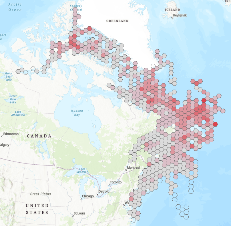
Sediment from Lakes Polycyclic aromatic hydrocarbons (PAHs), 47 elements including numerous metals, and visible reflectance spectroscopy or VRS-chla have been determined in sediment core samples collected in 2012, 2013 and 2014 from 16 small (surface area 4-97 ha; maximum depth ~1-5 m deep), hydrologically simple lakes located 30 to 120 km from major oil sands development areas. Canadian Council of Ministers of the Environment (CCME) guidelines are available for 13 of the 53 PAHs reported here. Sediment concentrations did not exceed Canadian Council of Ministers of the Environment (CCME) probable effects levels (PELs), which define the level above which biological adverse effects are expected to occur, for PAHs in any lake. Exceedances of the CCME interim sediment quality guidelines (ISQG) for the protection of aquatic life occurred for 4 PAHs (naphthalene, 2-methyl naphthalene phenanthrene, and benzo(a)pyrene) in 8 lakes. CCME sediment quality guidelines are available for 7 of the 47 elements reported here. Exceedances of the CCME ISQG for metals were found for arsenic in 3 lakes, cadmium in 8 lakes, mercury in 3 lakes and zinc in 9 lakes. Exceedances of the CCME PELs for metals occurred in 2 lakes for arsenic and 1 lake for zinc. Further assessment of the data is ongoing to examine reasons for exceedances as well as spatial and temporal trends of the PACs and elements. Analyses of lake primary productivity, using visible reflectance spectroscopy or VRS-chla as a proxy, show consistently greater productivity (i.e. VRS-chla concentrations) in the top sediment core slices relative to the bottom, regardless of lake morphological and limnological characteristics and landscape position. Potential drivers of these changes are being examined.
-
Oil Sands Sediment Exposures of Embryo-larval Fathead Minnows Dataset contains laboratory-studied fathead minnow egg and larval survival rates when exposed to sediments collected from 18 sites in the Athabasca watershed (2010-2014). A controlled laboratory study examined the impacts on fathead minnow eggs and larval development when exposed to collected sediments at concentrations of 1, 5 and/or 25 g/L. Sediments and water were renewed daily, and eggs were assessed as they hatched (in about 5 days), and as the larval fish grew to 8-9 days post hatch (dph), and 15-16 dph. The data in the file present the mean survival (and standard deviation). Two sediment sites caused decreased survival of fathead minnow fry: The Ells River lower site, and the Steepbank River Lower site. These data show that sediment from these sites can affect larval fish survival in the lab. The next steps are to compare these findings to the health data from wild fish collected from these same tributary sites. Toxicity Testing of Groundwater near the Oil Sands Development Dataset contains toxicity studies of groundwaters collected near the Athabasca and Ells rivers. Groundwaters were collected in the summer of 2013 from 4 sites below the riverbeds at depths of 0.5 to 1 metre. Sites were chosen to represent groundwaters close to oil sands tailings ponds and further from tailings ponds and mining activities. Under controlled laboratory conditions, fathead minnow eggs were exposed for 5 days (until hatch) to the groundwaters at standard dilution concentrations of 6, 12, 25, 50, and 100% of the groundwater sample to compare egg and larval fish survival. The data presents the average survival until hatch of 3 repeated exposures (and standard deviation) and 9 repeated exposures for controls. Some groundwater is toxic to minnows and some is not. No correlations were found between toxicity and proximity to a tailings pond. Assessing Toxicity of Oil Sands Related Substances Laboratory fish were exposed to melted snow from sites located close to oil sands mining and upgrading facilities and from sites far away from mining activities to assess the toxicity of substances found in the snow. In addition, river waters, bed sediments, suspended sediments, groundwater and atmospheric depositional samples (pre-melt snow collections) were also tested for toxicity. Fish exposed to undiluted snowmelt showed biological effects. Fish exposed to river water from the region collected during snowmelt conditions showed no effects.
-
Atmospheric Contaminant Deposition using Snowpack The data set includes snow samples (metals, water chemistry and polycyclic aromatic hydrocarbons [PAHs]). Data from 2012-2014 snowpack samples collected from ~90-130 sites located varying distances from the major oil sands development area show deposition patterns and levels consistent with earlier studies carried out in 2008 (Kelly et al. PNAS, 2009 and 2010). As with earlier findings, concentrations of numerous metals, water chemistry parameters (Ni, Pb, Zn, V, La, Al, Fe, total Hg, methyl Hg, total suspended solids [TSS], particulate organic carbon [POC], particulate organic nitrogen [PON], total phosphorus [TP]) and PAHs decrease with distance from the major mining extraction and upgrading facilities. Canadian Council of Ministers of the Environment (CCME) guidelines do not exist for snow.
-
Acid-Sensitive Lakes Nine hundred and thirty-three lakes located in Saskatchewan, Alberta and the Northwest Territories were sampled to establish current acidification status. Of the 933 lakes, 244 (or 26%) are considered acid sensitive, almost always because of naturally low calcium and magnesium (or "base cation") concentrations. The most acid-sensitive lakes (i.e., those with extremely low base cation concentrations) are located on the Canadian Shield in both Alberta and Saskatchewan and east of the oils sands development area. Fifty-one of the 244 acid-sensitive lakes were sampled twice annually (spring and fall) to identify chemical changes through trend analyses. Results revealed that 55% of these lakes had concentrations of some metals in excess of Canadian Council of Ministers of the Environment guidelines. Of the 291 samples taken in the 51 lakes, iron concentrations were greater than guidelines in 36% (105 samples), aluminum in 33% (97 samples), lead in 0.3% (1 sample) and copper in 0.3% (1 sample). The metals in these lakes occur naturally and are expected to be found in a wide range of concentrations given the geology and physiography of the Canadian Shield. It remains to establish the relationship between acid sensitivity, geology and high metal concentrations.
-
Seasonal and annual trends of relative total precipitation change (%) for 1948-2012 based on Canadian gridded data (CANGRD) are available, at a 50km resolution across Canada. The relative trends reflect the percent change in total precipitation over a period from the baseline value (defined as the average over 1961-1990 as the reference period). CANGRD data are interpolated from adjusted and homogenized climate station data (i.e., AHCCD datasets). Adjusted precipitation data incorporate adjustments to the original station data to account for discontinuities from non-climatic factors, such as instrument changes or station relocation.