
2007
Type of resources
Topics
Keywords
Contact for the resource
Provided by
Years
Formats
Representation types
Update frequencies
status
-

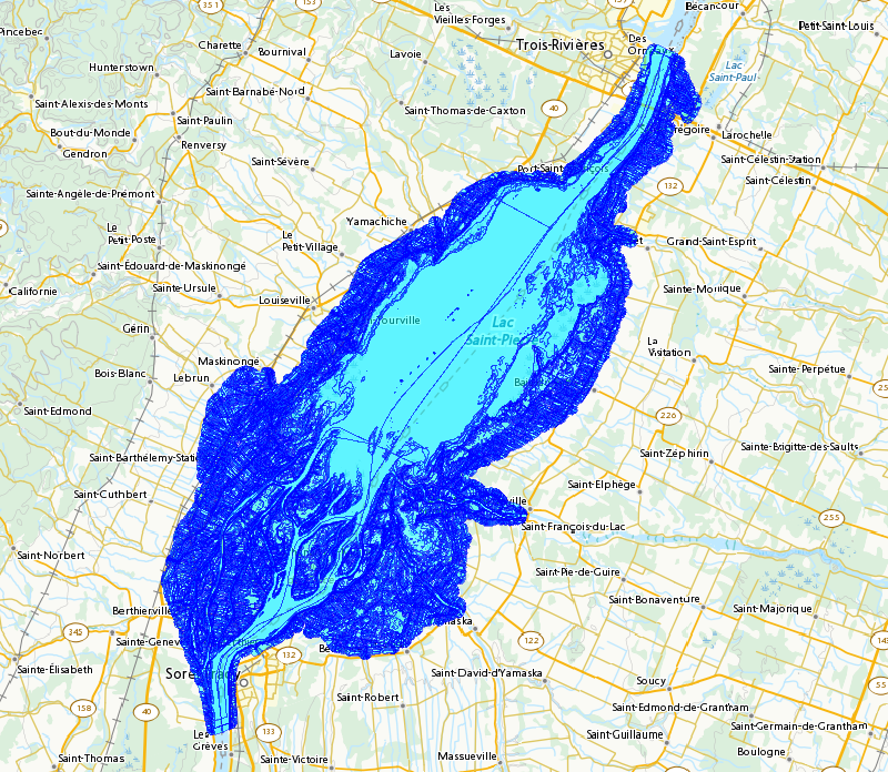
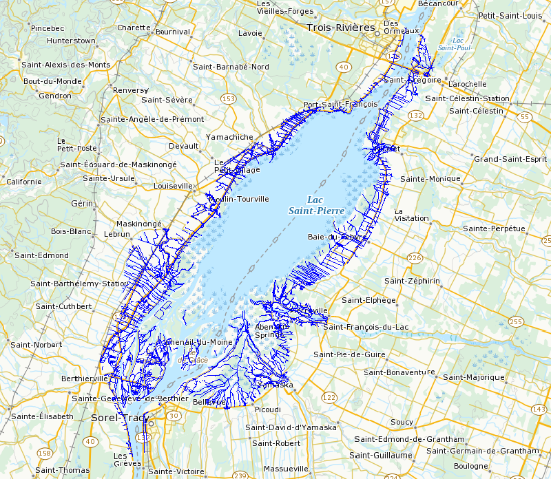
Recent efforts to model spring breeding habitats of fish in the St. Lawrence have revealed significant gaps in land use descriptions for the floodplains of Lac Saint-Pierre. In order to fill these gaps, aerial photographs taken in 1950, 1964 and 1997 were assembled in mosaic fashion and then digitized, georeferenced and interpreted to categorize 28 fish habitat classes. For each of the three periods, interpretation made it possible to categorize and georeference polygons (e.g. wet meadows, perennial crops) and linear elements (e.g. windbreaks, riparian strips, roads) and to compile these with their properties (habitat class, length, perimeter, surface area). To facilitate and refine subsequent analyses, all polygons and linear elements were delineated with the aid of several layers of information, including the boundaries of regional county municipalities, drainage basins, several flood scenarios, and three large units: the north and south shores of Lac Saint-Pierre and the Sorel archipelago. This report describes the methods used and the constraints encountered; it also presents certain interpretation limits and a summary analysis of habitat classes in the three periods studied. A temporal trend analysis of habitat dynamics in the three periods has yet to be completed. Source files containing the data have been published and are available to anyone interested in land use in the floodplains of Lac Saint-Pierre or wishing to extend the study of changes in these landscapes and habitats over the past fifty years, depending on their field of interest (e.g. fish habitats, waterfowl nesting, agricultural landscape).
-
Land use classification on the basis of multidate Landsat-ETM and Radarsat-1 images. Classification is based on the segmentation of images into objects using Definiens Earth software (formerly eCognition©). Object-oriented classification combines fuzzy logic, based on spectral, spatial and contextual properties (statistical functions of belonging), and, as a last resort, the manual identification of objects when automatic classification performs less well for certain objects. Targeted land use classes include agriculture (annual and perennial), the road system (expressways, roads, forest roads), the water system (permanent and non-permanent waterways and non-permanent ponds under forest cover), wetlands, urban areas, and forests. Top-to-bottom multiscale classification, reflecting an approach developed by the Canadian Wildlife Service, Quebec Division, in the context of the Canadian Wetlands Inventory (CWI), has been adapted for land use purposes. The methodological details of this classification approach were published in Grenier et al. 2007. Grenier, M., Demers, A.-M., Labrecque, S., Benoit, M., Fournier R., and Drolet B. 2007. An object-oriented method to map wetland using RADARSAT-1 and Landsat-ETM images: test case on two sites in Quebec, Canada. Canadian Journal of Remote Sensing, Vol. 33, Suppl. 1, pp. S28-S45.
-
Stormwater ponds have been widely used to control increased volumes and rates of surface runoff resulting from urbanization. Stormwater ponds have also been designed to provide multiple other benefits; including protection of downstream waters, sediment and habitat (land/aquatic) quality, provision of educational, recreational use as well as aesthetic amenities. Stormwater ponds create unique opportunities for enhancing community benefits, but they also cause ecological concerns with respect to the quality of the newly created habitat. Stormwater ponds receive untreated runoff from urban areas and transportation corridors, and such runoff transports sediment and pollutants from urban sources into the stormwater facilities. Built in the mid 1990s the Terraview and Willowfield stormwater ponds currently receive water and sediment runoff from 9 hectares of a 16-lane freeway and runoff from 30 hectares of residential lands. This dataset contains stormwater data from two stormwater ponds (Terraview and Willowfield) located within the Toronto and Region Area of concern (AOC). The data are water and sediment chemistry, and are used to evaluate the effectiveness of the two-stormwater ponds in providing a suitable habitat for aquatic species and wildlife species over a two-year period (2007 and 2008). Water and sediment samples were analyzed for trace metals such as calcium, nickel, and lead as well as 16 priority polycyclic aromatic hydrocarbons (PAHs).
-
The Turkey Lakes Watershed (TLW) Study was initiated in 1980 by Environment Canada, Natural Resources Canada and Fisheries and Oceans Canada to evaluate anthropogenic perturbation of Canadian Shield ecosystems. Originally, the Study focused on the aquatic and terrestrial effects of acid rain, but now it includes research into the effects of other anthropogenic pollutants (e.g. toxic contaminants) and ecological perturbations (e.g. forest harvesting, climate change and fish habitat modification).
-
Recent efforts to model spring breeding habitats of fish in the St. Lawrence have revealed significant gaps in land use descriptions for the floodplains of Lac Saint-Pierre. In order to fill these gaps, aerial photographs taken in 1950, 1964 and 1997 were assembled in mosaic fashion and then digitized, georeferenced and interpreted to categorize 28 fish habitat classes. For each of the three periods, interpretation made it possible to categorize and georeference polygons (e.g. wet meadows, perennial crops) and linear elements (e.g. windbreaks, riparian strips, roads) and to compile these with their properties (habitat class, length, perimeter, surface area). To facilitate and refine subsequent analyses, all polygons and linear elements were delineated with the aid of several layers of information, including the boundaries of regional county municipalities, drainage basins, several flood scenarios, and three large units: the north and south shores of Lac Saint-Pierre and the Sorel archipelago. This report describes the methods used and the constraints encountered; it also presents certain interpretation limits and a summary analysis of habitat classes in the three periods studied. A temporal trend analysis of habitat dynamics in the three periods has yet to be completed. Source files containing the data have been published and are available to anyone interested in land use in the floodplains of Lac Saint-Pierre or wishing to extend the study of changes in these landscapes and habitats over the past fifty years, depending on their field of interest (e.g. fish habitats, waterfowl nesting, agricultural landscape).
-
Water temperature data were collected by Environment and Climate Change Canada at selected locations in Lake Winnipeg.Thermograph moorings were deployed in the north basin at station 505 and 506, in the south basin at station 500, in the Lake Winnipeg Narrows at station 502, northwest of Berens Island at station 503 and north of Reindeer Island at station 504. This data was used in the hydrodynamic Estuary, Lake and Coastal Model (ELCOM) to predict water movement patterns and then coupled with the Computational Aquatic Ecosystem Dynamics Model (CAEDYM) to predict response to potential nutrient loading reduction actions to improve water quality in Lake Winnipeg.