
1980
Type of resources
Topics
Keywords
Contact for the resource
Provided by
Years
Formats
Representation types
Update frequencies
status
-
Continuous, year-round measurement of stream stage that is later converted to flow using a stage-discharge relationship occurs on at/near the lake outflows and 2 other stations along the principal watershed tributary, Norberg Creek. Measurements ended in 2016.
-
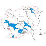
The Turkey Lakes Watershed (TLW) is 1 of 5 hydrologically "calibrated" basins in eastern Canada that were originally devoted to process-oriented research into "acid rain" effects. They were selected to cover a wide range of climatic and hydrological conditions, deposition magnitudes, and terrain characteristics. Batchawana Lake is the headwater (highest elevation) lake in the TLW. It has two distinct basins, north and south (L1 and L2). Norberg Creek flows out of Batchawana Lake South and traverses a large change in elevation (497-388 meters above mean sea level) prior to entering Wishart Lake (L3). Norberg Creek then continues through Little Turkey Lake (L4) and Turkey Lake (L5) and finally discharges into the Batchawana River and ultimately Lake Superior. The data associated to this page are separated into archival data from 1980 to 2006, and then data from 2006 to 2019.
-
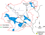
The snowpack has been sampled during both the accumulation and ablation stages at as many as 13 sites within the Turkey Lakes Watershed, Algoma, central Ontario, Canada since 1980, although more quantitative surveys began in 1989. Snow depth and a physical description of snowpack have been recorded at each station. Snow density, water equivalent and chemistry (major ions, pH and nutrients) have been determined. Since 2012, chemistry has only been completed on up to three sites although snow density and water equivalent have been measured at the others. The project completed in 2019.
-
The subjects of this study – the St. Lawrence (river, estuary and gulf) and the Ottawa and Richelieu rivers – present a range of natural shoreline habitats that are conducive to the flourishing of avian, aquatic and terrestrial fauna. Avian fauna, particularly migratory birds, use wetlands as feeding and resting areas. These wetlands develop primarily in bays that are sheltered from currents and their flora varies depending on water salinity and the presence or absence of tides. In the lowlands of the St. Lawrence, which are washed by fresh and brackish waters, wetlands contain submerged and emergent aquatic plants in areas unaffected by tidal action and are dominated by the American bulrush in areas where tidal variations uncover muddy sediments. They develop particularly well in areas where water in shallow, as in the bays of the Ottawa River, the shores of the Richelieu, and in the lakes, bays and island shores of the St. Lawrence. In salt water, they can be found in the fine deposits in the high areas of coves, bays and river mouths sheltered from violent seas. In the St. Lawrence estuary, low wetlands are dominated by Spartina alterniflora communities, while higher wetlands are characterized by the presence of Spartina patens and other halophyte communities. In the Gulf of St. Lawrence, wetland herbaceous species form mosaics of alternating halophyte communities. Photographic interpretation and mapping (1:20,000) of the shorelines of these waterways provide a means of locating wetlands, determining their size, and identifying disturbances of human origin. The results show that there are 39,000 hectares of these wetlands (submerged and emergent plants) in tideless freshwaters and approximately 3,900 hectares of herbaceous communities dominated by the American bulrush in tidal freshwaters. Identified saltwater wetlands represent a total of 9,000 hectares, 4,000 of which are found in the St. Lawrence estuary, 2,400 of which are distributed sporadically along the north shore of the Gulf of St. Lawrence and Gaspé Peninsula, and 2,200 of which are located in the Îles-de-la-Madeleine. Finally, an analysis of “control sectors” (La Prairie Basins, Gentilly and Kamouraska) along the St. Lawrence shows that the impact of major human interventions on the shorelines of these waterways has increased significantly over the past 30 years.
-
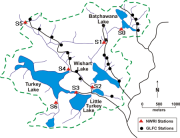
Water chemistry is measured at several stream stations in the Turkey Lakes Watershed (TLW) to quantify mass fluxes, cycling and budgets. Environment and Climate Change Canada (ECCC) tends to focus on lake outflow stations and other stations situated on Norberg Creek (the major drainage channel in the basin) while Natural Resources Canada (NRCan) tends to focus on headwater streams draining forested hill slopes. Monitoring began in 1980 but not all stations have complete records through to the present. Stream flow is measured continuously while water chemistry is measured intermittently. The frequency of chemical sampling is variable with daily sampling during periods of high flow (usually at spring melt) and bi-weekly sampling during low flow periods. The data associated to this page are separated into archival data from 1982-86 to 2006, and current data from 2007 to 2019.