

Type of resources
Topics
Keywords
Contact for the resource
Provided by
Years
Formats
Representation types
Update frequencies
status
-
Sidney Island Shorebird Surveys transects area feature.
-
Since 1988, the governments of Canada and Quebec have been working together to conserve, restore, protect and develop the St. Lawrence River under the St. Lawrence Action Plan (SLAP). One of the projects identified under the theme of biodiversity conservation is the development of an integrated plan for the conservation of the natural environments and biodiversity of the St. Lawrence River. The identification of priority sites for conservation has been the first step of this planning exercise. Conservation planning of natural environments requires a reliable, accurate and up-to-date image of the spatial distribution of ecosystems in the study area. In order to produce an Atlas of Priority Sites for Conservation in the St. Lawrence Lowlands, an updated cartography of the land cover of this vast territory was undertaken. This project required obtaining reliable information on the natural environments of the St. Lawrence Lowlands. Although several land cover mapping projects have been conducted for specific types of habitats, it was particularly important to obtain a homogeneous product that would cover the entire territory and that would provide the most detailed information on its various thematic components: agricultural, aquatic, human-modified and forest environments, wetlands as well as old fields and bare ground. The methodology used to produce the land cover mapping of the St. Lawrence Lowlands thus relied mainly on combining and enhancing the best existing products for each theme. This project was made in collaboration with MDDELCC as part of the St. Lawrence Action Plan (SLAP). This dataset includes land cover polygons within a 10 km radius of the Montréal administrative region.
-
Since 1988, the governments of Canada and Quebec have been working together to conserve, restore, protect and develop the St. Lawrence River under the St. Lawrence Action Plan (SLAP). One of the projects identified under the theme of biodiversity conservation is the development of an integrated plan for the conservation of the natural environments and biodiversity of the St. Lawrence River. The identification of priority sites for conservation has been the first step of this planning exercise. Conservation planning of natural environments requires a reliable, accurate and up-to-date image of the spatial distribution of ecosystems in the study area. In order to produce an Atlas of Priority Sites for Conservation in the St. Lawrence Lowlands, an updated cartography of the land cover of this vast territory was undertaken. This project required obtaining reliable information on the natural environments of the St. Lawrence Lowlands. Although several land cover mapping projects have been conducted for specific types of habitats, it was particularly important to obtain a homogeneous product that would cover the entire territory and that would provide the most detailed information on its various thematic components: agricultural, aquatic, human-modified and forest environments, wetlands as well as old fields and bare ground. The methodology used to produce the land cover mapping of the St. Lawrence Lowlands thus relied mainly on combining and enhancing the best existing products for each theme. This project was made in collaboration with MDDELCC as part of the St. Lawrence Action Plan (SLAP). This dataset includes land cover polygons within a 10 km radius of the Outaouais administrative region within the St. Lawrence Lowlands.
-
Surveyor shorebird bird observations and counts for all years.
-
Since 1988, the governments of Canada and Quebec have been working together to conserve, restore, protect and develop the St. Lawrence River under the St. Lawrence Action Plan (SLAP). One of the projects identified under the theme of biodiversity conservation is the development of an integrated plan for the conservation of the natural environments and biodiversity of the St. Lawrence River. The identification of priority sites for conservation has been the first step of this planning exercise. Conservation planning of natural environments requires a reliable, accurate and up-to-date image of the spatial distribution of ecosystems in the study area. In order to produce an Atlas of Priority Sites for Conservation in the St. Lawrence Lowlands, an updated cartography of the land cover of this vast territory was undertaken. This project required obtaining reliable information on the natural environments of the St. Lawrence Lowlands. Although several land cover mapping projects have been conducted for specific types of habitats, it was particularly important to obtain a homogeneous product that would cover the entire territory and that would provide the most detailed information on its various thematic components: agricultural, aquatic, human-modified and forest environments, wetlands as well as old fields and bare ground. The methodology used to produce the land cover mapping of the St. Lawrence Lowlands thus relied mainly on combining and enhancing the best existing products for each theme. This project was made in collaboration with MDDELCC as part of the St. Lawrence Action Plan (SLAP). This dataset includes land cover polygons within a 10 km radius of the Montérégie administrative region within the St. Lawrence Lowlands.
-
Monitor variations in seabird numbers and colony size in the St. Lawrence system. Survey of over 20 species of seabirds and herons during the breeding season, in order to monitor population dynamics through time and space. Seabird populations are influenced by food abundance and quality. There is actually more than 1,000,000 birds from more than 20 different species that breed in nearly 1,000 active colonies. Plongeon du Pacifique/Pacific Loon/Gavia Pacifica, Plongeon catmarin/Red-throated Loon/Gavia stellata, Macareux moine/Atlantic Puffin/Fratercula arctica, Guillemot à miroir/Black Guillemot/Cepphus grylle, Guillemot marmette/Common Murre/Uria aalge, Guillemot de Brünnich/Thick-billed Murre/Uria lomvia, Petit Pingouin/Razorbill/Alca torda, Mouette tridactyle/Black-legged Kittiwake/Rissa tridactyla, Goéland marin/Great Black-backed Gull/Larus marinus, Goéland argenté/Herring Gull/Larus argentatus, Goéland à bec cerclé/Ring-billed Gull/Larus delawarensis, Mouette rieuse/Common Black-headed Gull/Larus ridibundus, Sterne caspienne/Caspian Tern/Sterna caspia, Sterne pierregarin/Common Tern/Sterna hirundo, Sterne arctique/ArcticTern/Sterna paradisaea, Sterne de Dougall/Roseate Tern/Sterna dougallii, Océanite cul-blanc/Leach's Storm-Petrel/Oceanodroma leucorhoa, Fou de Bassan/Northern Gannet/Morus bassanus, Grand Cormoran/Great Cormorant/Phalacrocorax carbo, Cormoran à aigrettes/Double-crested Cormorant/Phalacrocorax auritus, Eider à duvet/Common Eider/Somateria mollissima, Grand Héron/Great Blue Heron/Ardea herodias, Bihoreau gris/Black-crowned Night-Heron/Nycticorax nycticorax.
-
Fish Status and Ecosystem Health - Caged Invertebrates In situ exposures of Hyalella azteca in Athabasca River tributaries - Summary of activities (2010, 2012, 2013, 2014) In situ exposures with Hyalella azteca were conducted within the oil sands region to assess differences in survival and growth of invertebrates caged at natural sites (i.e., exposed to naturally occurring sources of bitumen) compared to sites influenced by oil sands mining activity (i.e., exposed to both naturally occurring and anthropogenic sources of bitumen).Hyalella were collected from a wetland within the Athabasca River watershed but outside the area of oil sands development and activity. They were then placed in cages submerged at 3 sites on the Ells River, 3 sites on the Firebag River, and 4 sites on the Steepbank River. Five cages were deployed per site, each cage containing 20 Hyalella. Cages were removed two weeks after deployment, and Hyalella were counted and weighed as a group to determine growth. The data show no differences in survival or growth of Hyalella caged in situ at any of the 10 sites, when comparing natural sites to sites influenced by oil sands mining activity within each river (i.e., upstream to downstream sites) or between rivers. Caged Mussels Mature mussels (Pyganodon grandis) were collected from a site outside the oil development area (Clearwater River and Long Lake, Alberta) and placed into cages at various sites in the Athabasca River and tributaries for 4 to 6 weeks during the months of August, September and October 2012, 2013 and 2014. The data revealed that mussel growth and survival rates were not affected. Mussels exposed to river water for 4 to 6 weeks were less likely to survive when kept outside of the water for long periods of time (days). Further investigations are warranted to confirm these observations.
-
Environment and Climate Change Canada’s cause-effect monitoring is focused on understanding how boreal songbirds, including several Species at Risk, are affected by human activity in the oil sands area, particularly the impact of the physical disturbance of forested habitats from exploration, development and construction of oil sands. Determining the abundance of songbird species associated with various habitat type(s) and understanding how the type and number of birds varies with type and amount of habitat, are important components of assessing the effect of habitat disturbance. Regional-scale monitoring focuses on understanding how and why boreal songbirds, including several Species at Risk, are affected by human activity across the Peace, Athabasca and Cold Lake oil sands area. Local-scale projects focus on addressing gaps in our understanding of complex response patterns at regional scales by targeting specific habitats or development features of interest. These data contribute to: a. improving the design of monitoring programs; b. explaining observed trends in populations (why bird populations are increasing or decreasing); c. predicting population sizes within the oil sands area; and d. assessing the individual, additive and cumulative effects of oil sands and other resource development on boreal birds. Data are used by ECCC and our partners to develop new models and increase the robustness of existing models of bird responses to habitat and disturbance. Because models can be used to predict outcomes of future land management scenarios, these models can assist decision-making by helping evaluate land-use choices before impacts are directly observed.
-
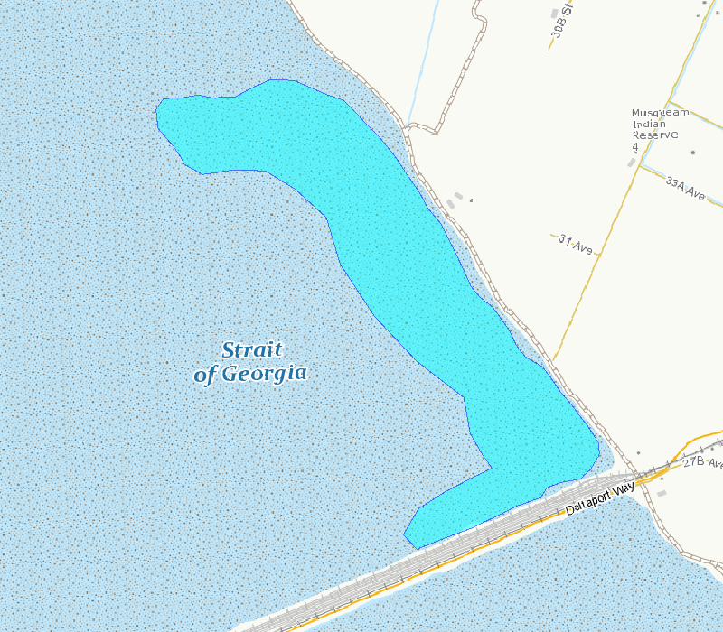
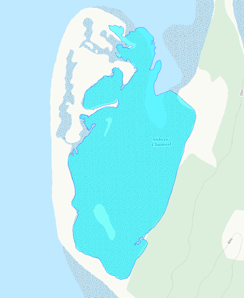
This polygon outlines the basic area included in the survey counts. This area is the best approximation of the mudflat that can be surveyed from shore and is exposed at tide tide height of 3.5 m, based on tidal predictions at Point Atkinson, British Columbia.
-
These surveys focus on two abundant shorebird species, Western Sandpiper (Calidris mauri) and Dunlin (Calidris alpina), and are conducted at a large mudflat on Roberts Bank, Delta, British Columbia, approximately 35 km south of Vancouver. These survey counts began in 1991 and are conducted annually during the northern migration period (April and May). Species-specific counts are derived from total flock counts multiplied by an estimate of percentage composition of the two species. The Brunswick Point study site (49°03′ N, 123°09′ W) extends over the southern third of Roberts Bank, and encompasses a large mudflat (tidal range = 0 – 3.8 m) separated from agricultural fields by a dike. Vegetation in the near shore sections of the mudflat is composed mostly of saltmarsh and bushes. Sediments in the mudflat range from soft mud to sand, and portions of the lower intertidal zone are covered with eelgrass (Zostera marina and Z. japonica). A causeway supporting a major port facility separates the mudflat from the remainder of Roberts Bank, and the dike is used for recreational purposes. Total flock counts. The number of total flock counts conducted annually varied from seven to 15 counts from 1991 to 1998. Beginning in 1999, counts were conducted either daily or every other day during spring migration for an annual replicate of 17 32 counts. The migration period began on 15 April each year and continued until lesser than 1000 birds were observed or until 15 May, whichever came first. This timing was chosen to overlap with the major pulse of Western Sandpiper migration and also captured peak Dunlin numbers. Daily timing of surveys depended on the tide cycle; the start of surveys ranged between 05:45 and 19:00 hr. Counts were conducted at a tide height of 3.5 m, based on tidal predictions at Point Atkinson, British Columbia. This tide height ensured birds were close to shore, with sufficient mudflat exposed to present good feeding opportunities for shorebirds. Occasionally maximum daily tide heights did not reach 3.5 m, and counts on these days were conducted during the actual maximum tide heights. Counts began at the southern end of the Brunswick Point dike where it meets the Roberts Bank Superport causeway. All birds visible on the mudflat were counted from a vehicle along a series of stops on the dike, for a total length of ~2.5 km. Birds were counted through a spotting scope mounted on the vehicle window, primarily for distant flocks, and through binoculars to count birds near the vehicle. Flocks were counted by an initial assessment of flock density, and then by counting blocks incrementally in 50s, 100s, 500s, or 1000s, according to flock size, in each successive field of view across a scan of the entire flock. In 1992, the number of birds in large flocks was estimated by multiplying the number of square metres of mudflat covered by the flock by the average number of sandpipers in several 1-m2 plots estimated by eye (Butler 1994). Species composition: Only total flock counts were conducted prior to 1997, as deriving species-specific counts was complicated by the intermixing of Western Sandpipers and Dunlin in the large flocks. Species-specific counts are calculated as a product of total flock counts and percentage composition of different species. From 1997 onwards, relative species composition (ratio of Western Sandpipers to Dunlins) was estimated during supplementary counts as birds settled on the mudflats before or after the main shorebird counts described above. Numbers of Western Sandpipers and Dunlins were individually tallied along visually estimated 1 m wide strips that ran perpendicular from the dike to the water’s edge, and included both open mudflat and shallow water. Tallies of all strip counts were summed and the species proportion for that day was calculated as the number of each species counted divided by the total number of birds.