
KMZ
Type of resources
Topics
Keywords
Contact for the resource
Provided by
Years
Formats
Representation types
Update frequencies
status
-
The Orbiting Carbon Observatory 2 (OCO-2) is a National Aeronautics and Space Administration (NASA) satellite launched in 2014. Although OCO-2 was not designed for monitoring power plant emissions, in some cases, carbon dioxide (CO2) observations from OCO-2 can be used to quantify daily CO2 emissions from individual coal power plants by fitting the data to plume model simulations. This data catalogue entry consists of the CO2 measurements by OCO-2 for the 7 power plant overpasses or flybys that were used for quantifying CO2 emissions in Nassar et al. (2017). This research affirms that a constellation of future CO2 imaging satellites, optimized for point sources, could monitor emissions from individual fossil fuel burning power plants to support the implementation of climate policies. Nassar, R., Hill, T. G., McLinden, C. A., Wunch, D., Jones, D. B. A., & Crisp, D. (2017). Quantifying CO2 emissions from individual power plants from space. Geophysical Research Letters, 44. https://doi.org/10.1002/2017GL074702
-
Canada has the longest coastline in the world, measuring 243,790 kilometers. Many of our waterways along the coastline have to be dredged regularly to keep shipping channels and harbours open and safe for navigation; and this material is sometimes best disposed of at sea. Schedule 5 of the Canadian Environmental Protection Act, 1999 (CEPA) defines an exclusive list of materials and substances suitable for disposal at sea in Canada, which is in accordance with the London Protocol (1996). They are: dredged material, fish waste resulting from industrial fish processing operations, ships or platforms, inert and inorganic geological matter, uncontaminated organic matter of natural origin, and bulky substances. The disposal of any substance into the sea, on the seabed, in the subsoil of the seabed, or onto ice, from a ship, an aircraft, a platform or other structure is not allowed unless a permit is issued by the Environment and Climate Change Canada (ECCC) Disposal at Sea Program. Incineration at sea, as well as importing or exporting a substance for disposal at sea is also prohibited. More information on Disposal at Sea is available at: https://www.canada.ca/en/environment-climate-change/services/disposal-at-sea.html The Active and Inactive Disposal at Sea Sites in Canadian Waters dataset provides spatial and related information of at-sea disposal sites approved for use in Canada in the last ten years and that remain open for consideration for additional use. Any additional use of a disposal site must be conducted in accordance with the terms and conditions of a valid Disposal at Sea permit. The dataset may be of use in relation to Disposal at Sea permit applications. For some Disposal at Sea permit applications the data may be of use in assessing serious harm to fish under the Fisheries Act and assessing interference with navigation under the Navigation Protection Act.
-
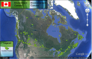
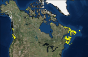
The Environmental Damages Fund (EDF), created by the Government of Canada in 1995, follows the Polluter Pays Principle to ensure that those who cause damage to the environment take responsibility for their actions. Prosecutors and judges can recommend that financial penalties (fines, awards and/or settlements) paid by environmental offenders are directed to the EDF, thereby helping to improve Canada’s natural environment. As the administrator of the EDF for the Government of Canada, Environment Canada assesses the funds received to ensure they respect conditions specified by the court, and relate as closely as possible to the nature of the environmental damage that resulted in funds being directed to EDF. Environment Canada’s Funding Program conducts Calls for Proposals to support community-based, non-profit organizations, and other eligible organizations for projects that have measureable and positive impact on the environment. The data enclosed is of the EDF Funded Projects since 2009. The map shows the projects in their relevant geographical locations in Google earth.
-
Canada has the longest coastline in the world, measuring 243,790 kilometers. Many of our waterways along the coastline have to be dredged regularly to keep shipping channels and harbours open and safe for navigation; and this material is sometimes best disposed of at sea. Schedule 5 of the Canadian Environmental Protection Act, 1999 (CEPA) defines an exclusive list of materials and substances suitable for disposal at sea in Canada, which is in accordance with the London Protocol (1996). They are: dredged material, fish waste resulting from industrial fish processing operations, ships or platforms, inert and inorganic geological matter, uncontaminated organic matter of natural origin, and bulky substances. The disposal of any substance into the sea, on the seabed, in the subsoil of the seabed, or onto ice, from a ship, an aircraft, a platform or other structure is not allowed unless a permit is issued by the Environment and Climate Change Canada (ECCC) Disposal at Sea Program. Incineration at sea, as well as importing or exporting a substance for disposal at sea is also prohibited. More information on Disposal at Sea is available at: https://www.canada.ca/en/environment-climate-change/services/disposal-at-sea.html The Active Disposal at Sea Sites in Canadian Waters dataset provides spatial and related information of at-sea disposal sites approved for use in Canada in the last ten years. Any additional use of a disposal site must be conducted in accordance with the terms and conditions of a valid Disposal at Sea permit. The dataset may be of use in relation to Disposal at Sea permit applications. For some Disposal at Sea permit applications the data may be of use in assessing serious harm to fish under the Fisheries Act and assessing interference with navigation under the Navigation Protection Act.
-
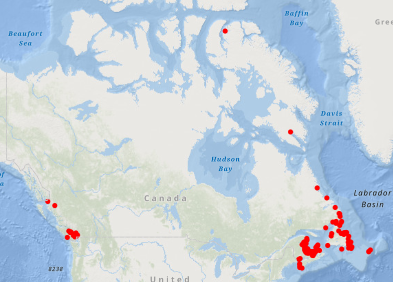
Sediment profile imagery (SPI) (also known as REMOTS (Rhoads and Germano, 1982)) facilitates the assessment of the biophysical processes that occur in the benthic environment through the acquisition and analysis of high resolution images of vertical sections and surfaces of the seafloor. The SPI apparatus incorporates the use of a 12-megapixel Digital SLR camera to obtain in situ photographs of the first 20 cm of the seafloor. Because the sediment is not disturbed in the process, SPI photographs provide information on the physical and biological components of the seabed that is not readily available using traditional methods. From 2012 to 2019, 17 SPI datasets were acquired at 13 disposal at sea sites in British Columbia to monitor the environmental conditions of the sea floor. SPI & surface photographs, tabular data, and a geodatabase with attachments are provided in zipfolders for each study.