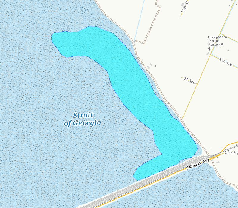
Roberts Bank Shorebird Surveys, British Columbia - Approx. Survey Area
This polygon outlines the basic area included in the survey counts. This area is the best approximation of the mudflat that can be surveyed from shore and is exposed at tide tide height of 3.5 m, based on tidal predictions at Point Atkinson, British Columbia.
Basic view
Metadata Record Information
- File Identifier
- 4cdeec34-30e7-4070-8362-ae5bac21376b XML
- Date Stamp
- 2025-01-31T13:44:02.203Z
- Metadata language
-
eng; CAN
- Character set
- UTF8
- Hierarchy Level
- Dataset
http://ec.gc.ca
Data identification
- Title
-
Roberts Bank Shorebird Surveys, British Columbia - Approx. Survey Area
- Date (Creation)
- 1991-04-15
- Date (Publication)
- 1991-04-15
- Status
- Completed
- Metadata language
-
eng; CAN
- Character set
- UTF8
- Topic category
-
- Biota
- Maintenance and Update Frequency
- Not planned
- Spatial representation type
- Vector
Keywords
- Theme
-
-
Brunswick Point
-
Shorebird Survey
-
Intertidal Flats
-
Fraser River Delta
-
Roberts Bank
-
Western Sandpiper
-
Species
-
-
Government of Canada Core Subject Thesaurus
-
-
Birds
-
-
ECCC Information Category EN
-
-
Nature and Biodiversity - Habitat
-
-
Business Functions
-
-
Protect and Restore Species
-
Protect Species Well-Being
-
-
Geography
-
-
British Columbia (BC)
-
-
external.theme.EC_Branch
-
-
Environmental Stewardship Branch
-
-
external.theme.EC_Directorate
-
-
Canadian Wildlife Service
-
-
external.theme.EC_Program_PAA
-
-
1.1.3. Migratory Birds
-
-
external.theme.GC_Security_Level
-
-
Unclassified
-
- Use Limitation
-
Open Government Licence - Canada ( http://open.canada.ca/en/open-government-licence-canada)
- Access Constraints
- License
- Use Constraints
- License
- Begin Date
- 1991-04-15
- End Date
- 2015-05-16
Extent
))
Ref. system Reference Systems
- Reference system identifier
- https://epsg.io / EPSG:4326 /
Distribution
Distribution Formats
- Distribution format
-
- SHP ( 1.0)
- CSV ( 1.0)
- JSON ( 1.0)
https://www.canada.ca/en/environment-climate-change.html
Overviews
Provided by
