Atlas of Seabirds at Sea in Eastern Canada 2006 - 2020
The atlas provides printable maps, Web Services and downloadable data files representing seabirds at-sea densities in eastern Canada.
The information provided on the open data web site can be used to identify areas where seabirds at sea are found in eastern Canada. However, low survey effort or high variation in some areas introduces uncertainty in the density estimates provided. The data and maps found on the open data web site should therefore be interpreted with an understanding of this uncertainty.
Data were collected using ships of opportunity surveys and therefore spatial and seasonal coverage varies considerably. Densities are computed using distance sampling to adjust for variation in detection rates among observers and survey conditions. Depending on conditions, seabirds can be difficult to identify to species level. Therefore, densities at higher taxonomic levels are provided. more details in the document: Atlas_SeabirdsAtSea-OiseauxMarinsEnMer.pdf.
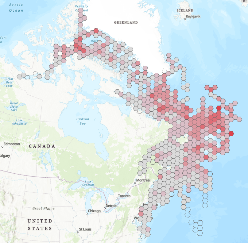
By clicking on "View on Map" you will visualize a example of the density measured for all species combined from April to July - 2006-2020. ESRI REST or WMS map services can be added to your web maps or opened directly in your desktop mapping applications. These are alternatives to downloading and provide densities for all taxonomical groups and species as well as survey effort.
Basic view
Metadata Record Information
- File Identifier
- f612e2b4-5c67-46dc-9a84-1154c649ab4e XML
- Date Stamp
- 2023-02-15T13:08:43
- Metadata language
-
eng; CAN
- Character set
- UTF8
- Hierarchy Level
- Dataset
http://ec.gc.ca
Data identification
- Date (Creation)
- 2016-11-15
- Date (Publication)
- 2022-05-31
- Status
- Completed
- Metadata language
-
eng
- Metadata language
-
fre
- Character set
- UTF8
- Topic category
-
- Biota
- Maintenance and Update Frequency
- As needed
- Spatial representation type
- Vector
Keywords
- Theme
-
-
inventory effort; bird density; Alcid; Gull;Jaegers; murres; murre; phalarope; shearwater; puffin; storm-petrel; oceanite; tern; skuas; labbe; atlantic puffin; black guillemot; cory's shearwater; common tern; dovekie; great black-backed gull; great shearwater; shearwater; herring gull; iceland gull; leach's storm-petrel; océanite cul-blanc; long-tailed jaeger; jaeger; labbe; labbe à longue queue; manx shearwater; puffin des anglais; northern fulmar; fulmar boréal; fulmar; northern gannet; fou de bassan; pomarine jaeger; labbe pomarin; raxorbill; petit pingouin; ring-billed gull; gull; red phalarope; red-throated loon; plongeon catmarin; sooty shearwater; thick-billed murre; wilson's storm petrel; océanite de wilson; black-legged kittiwake; mouette tridactyle; bonaparte's gull; common loon ; devekie; Seabirds; Migratory birds; Ocean; Oceans
-
-
Government of Canada Core Subject Thesaurus
-
-
Scientific information
-
Animals
-
Aquatic birds
-
Animal migrations
-
-
ECCC Information Category EN
-
-
Nature and Biodiversity
-
-
Geography
-
-
National (CA)
-
-
Business Functions
-
-
Assess Status of Species
-
Develop Species Recovery / Management / Conservation Plans
-
Protect Species Well-Being
-
Expand Scientific Knowledge / Develop New Methodologies for Assessing Site Conditions
-
-
local.theme.EC_Content_Scope
-
-
Species
-
-
external.theme.EC_Directorate
-
-
Canadian Wildlife Service
-
-
external.theme.EC_Program_PAA
-
-
1.1.3. Migratory Birds
-
-
external.theme.GC_Security_Level
-
-
Unclassified
-
- Use Limitation
-
Open Government Licence - Canada ( http://open.canada.ca/en/open-government-licence-canada )
- Access Constraints
- License
- Use Constraints
- License
- Begin Date
- 2006-06-01
- End Date
- 2020-06-17
Extent
))
Ref. system Reference Systems
- Reference system identifier
- http://www.epsg-registry.org / EPSG:4326 / Esri
Distribution
Distribution Formats
- Distribution format
-
-
FGDB/GDB
(
Unknown/Inconnue
)
-
FGDB/GDB
(
Unknown/Inconnue
)
http://ec.gc.ca
Overviews
Provided by