
FGDB/GDB
Type of resources
Topics
Keywords
Contact for the resource
Provided by
Years
Formats
Representation types
Update frequencies
status
-

This dataset provides geospatial polygon boundaries for marine bivalve shellfish harvest area classification in Canada (British Columbia, New Brunswick, Newfoundland and Labrador, Nova Scotia, Prince Edward Island and Quebec). These data represent the five classification categories of marine bivalve shellfish harvest areas (Approved; Conditionally Approved; Restricted; Conditionally Restricted; and Prohibited) under the Canadian Shellfish Sanitation Program (CSSP). Data are collected by Environment and Climate Change Canada (ECCC) for the purpose of making applicable classification recommendations on the basis of sanitary and water quality survey results. ECCC recommendations are reviewed and adopted by Regional Interdepartmental Shellfish Committees prior to regulatory implementation by Fisheries and Oceans Canada (DFO). These geographic data are for illustrative purposes only; they show shellfish harvest area classifications when in Open Status. The classification may be superseded at any time by regulatory orders issued by DFO, which place areas in Closed Status, due to conditions such as sewage overflows or elevated biotoxin levels. For further information about the current status and boundary coordinates for areas under Prohibition Order, please contact your local DFO office.
-

This dataset provides geospatial polygon boundaries for marine bivalve shellfish harvest area classification in Newfoundland and Labrador, Canada. These data represent the five classification categories of marine bivalve shellfish harvest areas (Approved; Conditionally Approved; Restricted; Conditionally Restricted; and Prohibited) under the Canadian Shellfish Sanitation Program (CSSP). Data are collected by Environment and Climate Change Canada (ECCC) for the purpose of making applicable classification recommendations on the basis of sanitary and water quality survey results. ECCC recommendations are reviewed and adopted by Regional Interdepartmental Shellfish Committees prior to regulatory implementation by Fisheries and Oceans Canada (DFO). These geographic data are for illustrative purposes only; they show shellfish harvest area classifications when in Open Status. The classification may be superseded at any time by regulatory orders issued by DFO, which place areas in Closed Status, due to conditions such as sewage overflows or elevated biotoxin levels. For further information about the current status and boundary coordinates for areas under Prohibition Order, please contact your local DFO office.
-
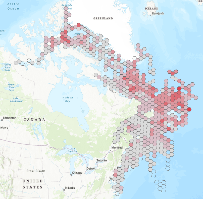
The atlas provides printable maps, Web Services and downloadable data files representing seabirds at-sea densities in eastern Canada. The information provided on the open data web site can be used to identify areas where seabirds at sea are found in eastern Canada. However, low survey effort or high variation in some areas introduces uncertainty in the density estimates provided. The data and maps found on the open data web site should therefore be interpreted with an understanding of this uncertainty. Data were collected using ships of opportunity surveys and therefore spatial and seasonal coverage varies considerably. Densities are computed using distance sampling to adjust for variation in detection rates among observers and survey conditions. Depending on conditions, seabirds can be difficult to identify to species level. Therefore, densities at higher taxonomic levels are provided. more details in the document: Atlas_SeabirdsAtSea-OiseauxMarinsEnMer.pdf. By clicking on "View on Map" you will visualize a example of the density measured for all species combined from April to July - 2006-2020. ESRI REST or WMS map services can be added to your web maps or opened directly in your desktop mapping applications. These are alternatives to downloading and provide densities for all taxonomical groups and species as well as survey effort.
-

This dataset provides marine bacteriological water quality data for bivalve shellfish harvest areas in British Columbia, Canada. Shellfish harvest area water temperature and salinity data are also provided as adjuncts to the interpretation of fecal coliform density data. The latter is the indicator of fecal matter contamination monitored annually by Environment and Climate Change Canada (ECCC) within the framework of the Canadian Shellfish Sanitation Program (CSSP). The geospatial positions of the sampling sites are also provided. These data are collected by ECCC for the purpose of making recommendations on the classification of shellfish harvest area waters. ECCC recommendations are reviewed and adopted by Regional Interdepartmental Shellfish Committees prior to regulatory implementation by Fisheries and Oceans Canada (DFO).
-

This dataset provides marine bacteriological water quality data for bivalve shellfish harvest areas in Canada (British Columbia, New Brunswick, Newfoundland and Labrador, Nova Scotia, Prince Edward Island and Quebec). Shellfish harvest area water temperature and salinity data are also provided as adjuncts to the interpretation of fecal coliform density data. The latter is the indicator of fecal matter contamination monitored annually by Environment and Climate Change Canada (ECCC) within the framework of the Canadian Shellfish Sanitation Program (CSSP). The geospatial positions of the sampling sites are also provided. These data are collected by ECCC for the purpose of making recommendations on the classification of shellfish harvest area waters. ECCC recommendations are reviewed and adopted by Regional Interdepartmental Shellfish Committees prior to regulatory implementation by Fisheries and Oceans Canada (DFO).
-

This dataset provides marine bacteriological water quality data for bivalve shellfish harvest areas in Newfoundland and Labrador, Canada. Shellfish harvest area water temperature and salinity data are also provided as adjuncts to the interpretation of fecal coliform density data. The latter is the indicator of fecal matter contamination monitored annually by Environment and Climate Change Canada (ECCC) within the framework of the Canadian Shellfish Sanitation Program (CSSP). The geospatial positions of the sampling sites are also provided. These data are collected by ECCC for the purpose of making recommendations on the classification of shellfish harvest area waters. ECCC recommendations are reviewed and adopted by Regional Interdepartmental Shellfish Committees prior to regulatory implementation by Fisheries and Oceans Canada (DFO).
-

This dataset provides geospatial polygon boundaries for marine bivalve shellfish harvest area classification in British Columbia, Canada. These data represent the five classification categories of marine bivalve shellfish harvest areas (Approved; Conditionally Approved; Restricted; Conditionally Restricted; and Prohibited) under the Canadian Shellfish Sanitation Program (CSSP). Data are collected by Environment and Climate Change Canada (ECCC) for the purpose of making applicable classification recommendations on the basis of sanitary and water quality survey results. ECCC recommendations are reviewed and adopted by Regional Interdepartmental Shellfish Committees prior to regulatory implementation by Fisheries and Oceans Canada (DFO). These geographic data are for illustrative purposes only; they show shellfish harvest area classifications when in Open Status. The classification may be superseded at any time by regulatory orders issued by DFO, which place areas in Closed Status, due to conditions such as sewage overflows or elevated biotoxin levels. For further information about the current status and boundary coordinates for areas under Prohibition Order, please contact your local DFO office.
-

This dataset provides marine bacteriological water quality data for bivalve shellfish harvest areas in New Brunswick, Canada. Shellfish harvest area water temperature and salinity data are also provided as adjuncts to the interpretation of fecal coliform density data. The latter is the indicator of fecal matter contamination monitored annually by Environment and Climate Change Canada (ECCC) within the framework of the Canadian Shellfish Sanitation Program (CSSP). The geospatial positions of the sampling sites are also provided. These data are collected by ECCC for the purpose of making recommendations on the classification of shellfish harvest area waters. ECCC recommendations are reviewed and adopted by Regional Interdepartmental Shellfish Committees prior to regulatory implementation by Fisheries and Oceans Canada (DFO).
-

This dataset provides geospatial polygon boundaries for marine bivalve shellfish harvest area classification in Quebec, Canada. These data represent the five classification categories of marine bivalve shellfish harvest areas (Approved; Conditionally Approved; Restricted; Conditionally Restricted; and Prohibited) under the Canadian Shellfish Sanitation Program (CSSP). Data are collected by Environment and Climate Change Canada (ECCC) for the purpose of making applicable classification recommendations on the basis of sanitary and water quality survey results. ECCC recommendations are reviewed and adopted by Regional Interdepartmental Shellfish Committees prior to regulatory implementation by Fisheries and Oceans Canada (DFO). These geographic data are for illustrative purposes only; they show shellfish harvest area classifications when in Open Status. The classification may be superseded at any time by regulatory orders issued by DFO, which place areas in Closed Status, due to conditions such as sewage overflows or elevated biotoxin levels. For further information about the current status and boundary coordinates for areas under Prohibition Order, please contact your local DFO office.
-
As part of a scientific assessment of critical habitat for boreal woodland caribou (Environment Canada 2011, see full reference in accompanying documentation), Environment Canada's Landscape Science and Technology Division was tasked with providing detailed anthropogenic disturbance mapping, across known caribou ranges, as of 2015. This data comprises a 5-year update to the mapping of 2008-2010 disturbances, and allows researchers to better understand the attributes that have a known effect on caribou population persistence. The original disturbance mapping was based on 30-metre resolution Landsat-5 imagery from 2008 -2010. The mapping process used in 2010 was repeated using 2015 Landsat imagery to create a nationally consistent, reliable and repeatable geospatial dataset that followed a common methodology. The methods developed were focused on mapping disturbances at a specific point of time, and were not designed to identify the age of disturbances, which can be of particular interest for disturbances that can be considered non-permanent, for example cutblocks. The resultant datasets were used for a caribou resource selection function (habitat modeling) and to assess overall disturbance levels on each caribou ranges. Anthropogenic disturbances within 51 caribou ranges across Canada were mapped. The ranges were defined by individual provinces and territories across Canada. Disturbances were remapped across these ranges using 2015 Landsat-8 satellite imagery to provide the most up-to-date data possible. As with the 2010 mapping project, anthropogenic disturbance was defined as any human-caused disturbance to the natural landscape that could be visually identified from Landsat imagery with 30-metre multi-band imagery at a viewing scale of 1:50,000. A minimum mapping unit MMU of 2 ha (approximately 22 contiguous 30-metre pixels) was selected. Each disturbance feature type was represented in the database by a line or polygon depending on their geometric description. Polygonal disturbances included: cutblocks, mines, reservoirs, built-up areas, well sites, agriculture, oil and gas facilities, as well as unknown features. Linear disturbances included: roads, railways, powerlines, seismic exploration lines, pipelines, dams, air strips, as well as unknown features. For each type of anthropogenic disturbance, a clear description was established (see Appendix 7.2 of the science assessment) to maintain consistency in identifying the various disturbances in the imagery by the different interpreters. Features were only digitized if they were visible in the Landsat imagery at the prescribed viewing scale. A 2nd interpreter quality-control phase was carried out to ensure high quality, complete and consistent data collection. For this 2015 update an additional, separate higher-resolution database was created by repeating the process using 15-metre panchromatic imagery. For the 30-metre database only, the line and poly data were buffered by a 500-metre radius, representing their extended zone of impact upon boreal caribou herds. Additionally, forest fire polygons were merged into the anthropogenic footprint in order to create an overall disturbance footprint. These buffered datasets were used in the calculation of range disturbance levels and for integrated risk assessment analysis.