
location
Type of resources
Topics
Keywords
Contact for the resource
Provided by
Years
Formats
Representation types
Update frequencies
status
-
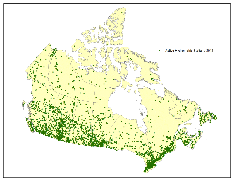
1. Provides public access to station metadata of hydrometric monitoring locations (active and discontinued); 2. Provides public access to the hydrometric station index listed in stream order beginning with the most upstream stations and extending to the most downstream stations.
-
Sediment profile imagery (SPI) (also known as REMOTS (Rhoads and Germano, 1982)) facilitates the assessment of the biophysical processes that occur in the benthic environment through the acquisition and analysis of high resolution images of vertical sections and surfaces of the seafloor. The SPI apparatus incorporates the use of a 12-megapixel Digital SLR camera to obtain in situ photographs of the first 20 cm of the seafloor. Because the sediment is not disturbed in the process, SPI photographs provide information on the physical and biological components of the seabed that is not readily available using traditional methods. From 2012 to 2019, 17 SPI datasets were acquired at 13 disposal at sea sites in British Columbia to monitor the environmental conditions of the sea floor. SPI & surface photographs, tabular data, and a geodatabase with attachments are provided in zipfolders for each study.
-
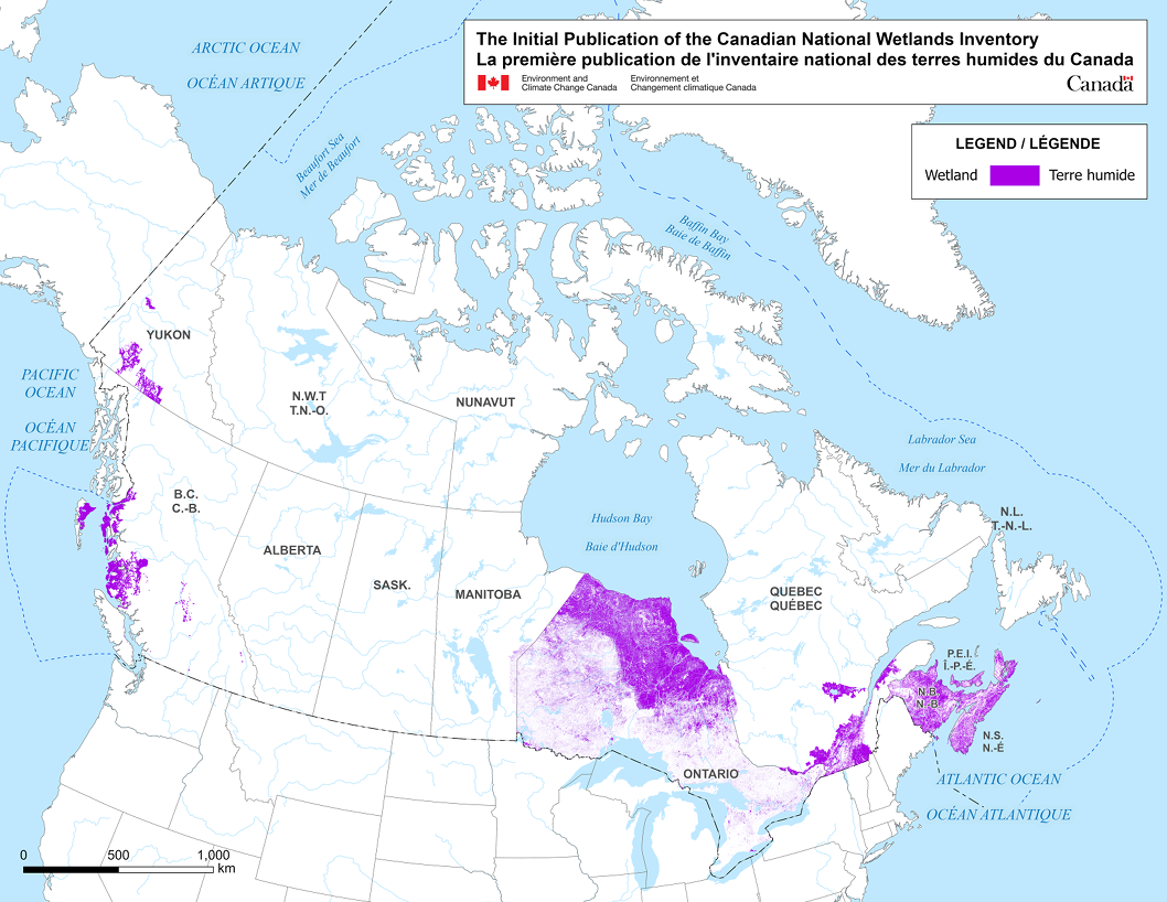
The Canadian National Wetlands Inventory (CNWI) is a comprehensive publicly available national geodatabase developed by the Canadian Wildlife Services (CWS) of Environment and Climate Change Canada (ECCC), in collaboration with federal, provincial, territorial, academia, indigenous groups and Non-governmental organizations (NGOs). It consists of the best available wetland mapping and ground-truth data, along with its metadata, published in a standardized manner. Over time, not only existing data being complied but also new high-resolution data will be acquired to fill priority gaps in coverage, with an emphasis on peatlands and coastal wetlands. ECCC plans to use the CNWI to train and validate machine-learning algorithms to delineate and classify wetlands at a national scale and measure trends over time. This will support Canada’s Nature-Based Climate Solutions by informing biodiversity conservation, climate change mitigation and adaptation, and reporting on greenhouse gas (GHG) emission reduction. In 2022-2023, CWS selected 30 candidate datasets to include in the CNWI, out of over 50 datasets where an initial assessment was completed. As of December 2023, the CNWI includes 13 source datasets as depicted in Figure 1, gathered from seven provinces/territories (BC, NB, NS, PEI, ON, QC, YK), which comprise approximately 4.1 million wetland polygon features and covers approximately 40 million hectares. The source datasets are available by province/territory. These source datasets were cross-walked into a standardized CNWI Classification Schema, which was built on two foundational documents: the Canadian Wetland Classification System (National Wetlands Working Group, 1997) and Canadian Wetland Inventory (Data Model, 2016). The CNWI Schema contains five major wetland classes: Bog, Fen, Swamp, Marsh, Shallow / Open Water, and eight subclasses: Rich Fen, Poor Fen, Organic Swamp, Mineral Swamp, Organic Marsh, Mineral Marsh, Shallow Water, and Open Water. Non-conforming wetlands can be categorized into three groups: Peatland, Mixed, and Unclassified. For more information on the CNWI and related database, please refer to the CNWI User Manual and other supporting documents that accompanies this publication.