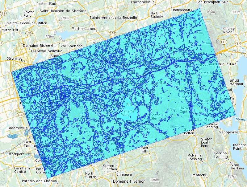
Land cover mapping of lake Brome using Landsat-ETM and RADARSAT-1 imagery, 2007
Land use classification on the basis of multidate Landsat-ETM and Radarsat-1 images. Classification is based on the segmentation of images into objects using Definiens Earth software (formerly eCognition©). Object-oriented classification combines fuzzy logic, based on spectral, spatial and contextual properties (statistical functions of belonging), and, as a last resort, the manual identification of objects when automatic classification performs less well for certain objects. Targeted land use classes include agriculture (annual and perennial), the road system (expressways, roads, forest roads), the water system (permanent and non-permanent waterways and non-permanent ponds under forest cover), wetlands, urban areas, and forests. Top-to-bottom multiscale classification, reflecting an approach developed by the Canadian Wildlife Service, Quebec Division, in the context of the Canadian Wetlands Inventory (CWI), has been adapted for land use purposes. The methodological details of this classification approach were published in Grenier et al. 2007.
Grenier, M., Demers, A.-M., Labrecque, S., Benoit, M., Fournier R., and Drolet B. 2007. An object-oriented method to map wetland using RADARSAT-1 and Landsat-ETM images: test case on two sites in Quebec, Canada. Canadian Journal of Remote Sensing, Vol. 33, Suppl. 1, pp. S28-S45.
Basic view
Metadata Record Information
- File Identifier
- 2bb38813-5cd0-40e9-a729-7c3ab460d2f5 XML
- Date Stamp
- 2022-06-29T16:31:54
- Metadata language
-
fra; CAN
- Character set
- UTF8
- Hierarchy Level
- Series
http://ec.gc.ca
Data identification
- Title
-
Land cover mapping of lake Brome using Landsat-ETM and RADARSAT-1 imagery, 2007
- Date (Creation)
- 2007-04-18
- Date (Publication)
- 2018-04-17
- Status
- Completed
- Metadata language
-
fra; CAN
- Character set
- UTF8
- Topic category
-
- Environment
- Maintenance and Update Frequency
- Not planned
- Spatial representation type
- Vector
Keywords
- Theme
-
-
Land cover
-
Landsat-ETM
-
RADARSAT-1
-
Object-based classification
-
- Place
-
-
Brome lake
-
-
ECCC Information Category EN
-
-
Nature and Biodiversity - Habitat
-
-
Geography
-
-
Quebec (QC)
-
-
Government of Canada Core Subject Thesaurus
-
-
Remote sensing
-
Geography
-
-
Business Functions
-
-
Oversee and Manage Site Conditions
-
Expand Scientific Knowledge / Develop New Methodologies for Assessing Site Conditions
-
-
Branch
-
-
Environmental Stewardship Branch
-
-
Directorate
-
-
Canadian Wildlife Service
-
-
local.theme.EC_Content_Scope
-
-
Geographic Feature
-
- Use Limitation
-
Open Government Licence - Canada ( http://open.canada.ca/en/open-government-licence-canada)
- Access Constraints
- License
- Use Constraints
- License
- Begin Date
- 1998-01-01
- End Date
- 2002-12-31
Extent
))
Ref. system Reference Systems
- Reference system identifier
- http://www.epsg-registry.org / EPSG:4326 /
Distribution
Distribution Formats
- Distribution format
-
- SHP ( N/A)
http://ec.gc.ca
Overviews

)))
Provided by
