
1968
Type of resources
Topics
Keywords
Contact for the resource
Provided by
Years
Formats
Representation types
Update frequencies
status
-
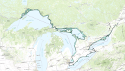
The Great Lakes Migrant Waterfowl Surveys provide periodic data on waterfowl abundance, spatial and temporal distributions, and use along the shorelines of major water bodies and river systems in Ontario during mostly during spring and fall, and to a lesser extent during summer and winter, seasons. The primary survey area covers the shoreline and nearshore (~1km) waters of the Lower Great Lakes region of Ontario, specifically including the St. Lawrence River, Lake Ontario, Niagara River, Lake Erie, Detroit River and Lake St. Clair and associated major marshes and embayments. Aerial surveys, typically flown several times within spring (March –May: 1969, 1971, 1972, 1975 –1979, 1981, 1982, 1984 –1988, 1991 –1996, 1998 –2003 & 2009 –2011) and fall (September –December: 1968, 1970, 1971, 1974 –2003 & 2009 –2011) survey periods, have been conducted periodically on a relatively regular basis (approx. 5-10 years) along the Lower Great Lakes shorelines between 1968 and 2011. Smaller-scale surveys also have been conducted periodically during summer (June –August: 1968 –1970, 1972, 1974, 1975, 1977, 1982, 1984, 1986, 1989, 1999 & 2002) in this region. This survey often has been conducted in conjunction with the Midwinter Survey, so its data (up to 2004) also are included in the CWS Migrant Waterfowl Surveys database (Year ≥2004 & Month = January & February).Data from several aerial surveys conducted periodically during the non-breeding period outside the Lower Great Lakes region also are included in this database. Spring and fall surveys have been conducted along the shorelines and nearshore waters of the Upper Great Lakes region of Ontario, specifically at St. Clair River (Fall 2012 & 2013), Lake Huron (Fall 1973, 1996; Spring 1974) / Georgian Bay (Fall 1973, 1996, 2012 & 2013) & Lake Superior (Fall 2000). Aerial surveys also have been conducted inland in southeastern Ontario along the Rideau River (Fall 1998 & Spring 1999).