
RI_533
Type of resources
Topics
Keywords
Contact for the resource
Provided by
Years
Formats
Representation types
Update frequencies
status
-
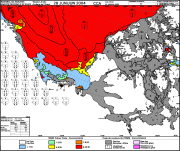
The Canadian Ice Service maintains a collection of Daily ice charts, Regional ice charts and Iceberg charts. These charts are available in GIF format and E00 (Regional Charts only).
-
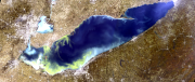
This dataset contains lake-wide algal bloom indices (extent, intensity, and severity) of Lake Erie on a daily basis over the June through October monitoring season. These data are derived from satellite remote sensing algorithms using European Space Agency's (ESA's) MEdium Resolution Imaging Spectrometer (MERIS) sensor on the Envisat satellite (2002-2012) and ESA's Ocean and Land Colour Instrument (OLCI) sensor on the Sentinel 3A and Sentinel 3B satellites (2016-present). Citation: Binding, C.E., Pizzolato, L., & Zeng, C. (2021). EOLakeWatch; delivering a comprehensive suite of remote sensing algal bloom indices for enhanced monitoring of Canadian eutrophic lakes. Ecological Indicators, 121, 106999. doi:10.1016/j.ecolind.2020.106999
-
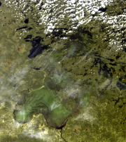
This dataset contains lake-wide algal bloom indices (extent, intensity, and severity) of Lake of the Woods on a daily basis over the June through October monitoring season. These data are derived from satellite remote sensing algorithms using European Space Agency's (ESA's) MEdium Resolution Imaging Spectrometer (MERIS) sensor on the Envisat satellite (2002-2012) and ESA's Ocean and Land Colour Instrument (OLCI) sensor on the Sentinel 3A and Sentinel 3B satellites (2016-present). Citation: Binding, C.E., Pizzolato, L., & Zeng, C. (2021). EOLakeWatch; delivering a comprehensive suite of remote sensing algal bloom indices for enhanced monitoring of Canadian eutrophic lakes. Ecological Indicators, 121, 106999. doi:10.1016/j.ecolind.2020.106999
-
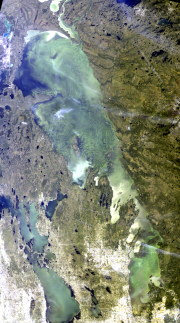
This dataset contains lake-wide algal bloom indices (extent, intensity, and severity) of Lake Winnipeg on a daily basis over the June through October monitoring season. These data are derived from satellite remote sensing algorithms using European Space Agency's (ESA's) MEdium Resolution Imaging Spectrometer (MERIS) sensor on the Envisat satellite (2002-2012) and ESA's Ocean and Land Colour Instrument (OLCI) sensor on the Sentinel 3A and Sentinel 3B satellites (2016-present). Citation: Binding, C.E., Pizzolato, L., & Zeng, C. (2021). EOLakeWatch; delivering a comprehensive suite of remote sensing algal bloom indices for enhanced monitoring of Canadian eutrophic lakes. Ecological Indicators, 121, 106999. doi:10.1016/j.ecolind.2020.106999