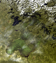
Lake of the Woods Satellite-derived Daily Algal Bloom Indices
This dataset contains lake-wide algal bloom indices (extent, intensity, and severity) of Lake of the Woods on a daily basis over the June through October monitoring season. These data are derived from satellite remote sensing algorithms using European Space Agency's (ESA's) MEdium Resolution Imaging Spectrometer (MERIS) sensor on the Envisat satellite (2002-2012) and ESA's Ocean and Land Colour Instrument (OLCI) sensor on the Sentinel 3A and Sentinel 3B satellites (2016-present).
Citation: Binding, C.E., Pizzolato, L., & Zeng, C. (2021). EOLakeWatch; delivering a comprehensive suite of remote sensing algal bloom indices for enhanced monitoring of Canadian eutrophic lakes. Ecological Indicators, 121, 106999. doi:10.1016/j.ecolind.2020.106999
Basic view
Metadata Record Information
- File Identifier
- 2f2a8706-5436-46d2-b1b3-876edd0db389 XML
- Date Stamp
- 2022-06-29T19:50:05
- Metadata language
-
eng; CAN
- Character set
- UTF8
- Hierarchy Level
- Dataset
https://www.canada.ca/en/environment-climate-change.html
Data identification
- Date (Creation)
- 2019-07-26
- Date (Publication)
- 2019-11-20
- Status
- On going
- Metadata language
-
eng; CAN
- Character set
- UTF8
- Topic category
-
- Inland waters
- Maintenance and Update Frequency
- Daily
- Spatial representation type
- Text, table
Keywords
- Theme
-
-
Algal Bloom
-
Observation/Measurement
-
Earth Observation
-
Algae
-
Chlorophyll
-
- Place
-
-
Lake of the Woods
-
- Discipline
-
-
Remote Sensing
-
-
Government of Canada Core Subject Thesaurus
-
-
Water quality
-
-
ECCC Information Category EN
-
-
Water - Quality
-
-
Business Functions
-
-
Expand Scientific Knowledge / Develop New Methodologies for Assessing Site Conditions
-
Oversee and Manage Site Conditions
-
-
Geography
-
-
Water - Drainage regions - Winnipeg
-
Ontario (ON)
-
-
external.theme.EC_Branch
-
-
Science and Technology Branch
-
-
external.theme.EC_Directorate
-
-
Water Science and Technology
-
-
external.theme.GC_Security_Level
-
-
Unclassified
-
- Use Limitation
-
Open Government Licence - Canada ( http://open.canada.ca/en/open-government-licence-canada )
- Access Constraints
- License
- Use Constraints
- License
- Begin Date
- 2002-06-01
Extent
))
Ref. system Reference Systems
- Reference system identifier
- http://www.epsg-registry.org / EPSG:3978 /
Distribution
Distribution Formats
- Distribution format
-
-
CSV
(
2016
)
-
CSV
(
2016
)
https://www.canada.ca/en/environment-climate-change.html
Overviews


Provided by