
1960
Type of resources
Topics
Keywords
Provided by
Years
Formats
Representation types
Update frequencies
status
-
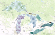
The Great Lakes Sediment Database (also known as the National Water Research Institute (NWRI) Sediment Archive) is an archive of data on the sediments of the Great Lakes, their connecting channels, and the St. Lawrence River which was collected by NWRI and in cooperation with other agencies between 1960 and 1975. It is housed in Environment and Climate Change Canada's Canada Centre for Inland Waters in Burlington, Ontario. The data has been subdivided into two groups according to location and purpose: 1.Great Lakes Basin Sediment Data: physical and geochemical data for sediment samples and cores collected lakewide in lakes Ontario, Erie, St. Clair, Huron (including Georgian Bay), Michigan and Superior between 1960 and 1975 by R.L. Thomas, A.L.W. Kemp and C.F.M. Lewis of NWRI. The data includes descriptions of sediment and core properties, grain-size statistics and sediment geochemistry; 2. Nearshore Sediments Data: physical data for samples and cores, bathymetry, and sediment thickness collected in the Canadian nearshore zone of lakes Ontario, Erie, St. Clair, Huron and Georgian Bay between 1960 and 1975. The data includes descriptions of sediment and core properties, grain-size statistics, sediment patterns and x-radiographs of sediment cores. Underwater photographs are also available for Lake Huron and Georgian Bay. The database was prepared to preserve historic and current sediment data and make it available for research, remediation, lake and shoreline management, habitat studies and engineering projects. Because the basin and nearshore surveys were the first systematic and detailed surveys of both zones, their data should also be useful for studies of trends in physical properties, sediment transport, and contamination or trophic levels. The sediment-sample archive serves the same purpose by making historic samples available for analysis of changes in composition or geotechnical properties.