March 2013 Bathymetric Survey of the Black Point Dredged Material Disposal Site, Saint John Harbour, NB
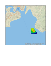
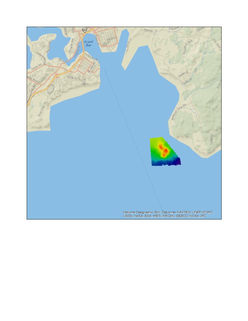
Each year in Canada between two and four million tonnes of materials are disposed of at marine disposal sites. The majority of these materials is dredged sediment from estuarine or marine locations. Under the authority provided by the Canadian Environmental Protection Act 1999, Environment Canada regulates the use of marine disposal sites and monitors environmental conditions at representative sites. Monitoring assesses on-site and off-site environmental effects such as changes to seabed morphology, environmental quality, habitat alteration and cumulative effects. In March 2013, as part of its Disposal Site Monitoring Program, Environment Canada contracted Public Works and Government Services Canada to conduct a bathymetric survey of the Black Point Dredged Material Disposal Site. The disposal site is located in the outer waters of Saint John Harbour, NB and over a period of several decades has received dredged materials from various locations in the harbour. The survey covered a trapezoidal area of approximately 2 square kilometers ranging in depth from 5 to 27 meters. Survey equipment used included a 200 kHz multi-beam system, inertial motion sensor, and sound velocity profiler. The multi-beam data was post-processed using hydrographic processing software. Data are available in a number of mapping formats.
Data were collected for environmental monitoring purposes and are not to be used for navigation.
Basic view
Metadata Record Information
- File Identifier
- ef3aa798-83b5-42cc-b665-82a3e0976503 XML
- Date Stamp
- 2022-01-21T21:04:36
- Metadata language
-
eng; CAN
- Character set
- UTF8
- Hierarchy Level
- Dataset
http://ec.gc.ca
Data identification
- Title
-
March 2013 Bathymetric Survey of the Black Point Dredged Material Disposal Site, Saint John Harbour, NB
- Date (Publication)
- 2013-04-25
- Date (Creation)
- 2013-03-10
- Date (Creation)
- 2013-03-25
- Status
- Completed
- Metadata language
-
eng; CAN
- Character set
- UTF8
- Topic category
-
- Environment
- Geoscientific information
- Oceans
- Maintenance and Update Frequency
- Not planned
- Spatial representation type
- Vector
Keywords
- Theme
-
-
Dredged Material
-
Geographic Feature
-
Marine Disposal Site
-
Mapping
-
Bathymetry
-
Ocean Terrain
-
- Place
-
-
Saint John Harbour, New Brunswick
-
Black Point
-
- Temporal
-
-
2013
-
- Discipline
-
-
Disposal At Sea
-
Marine Pollution
-
-
ECCC Information Category EN
-
-
Pollution and Waste
-
-
Geography
-
-
Atlantic - New Brunswick (NB)
-
-
Government of Canada Core Subject Thesaurus
-
-
Surveys
-
Surficial geology
-
Ocean floor
-
-
external.theme.EC_Branch
-
-
Environmental Stewardship Branch
-
-
external.theme.EC_Directorate
-
-
Environmental Protection Operations
-
-
external.theme.EC_Program_PAA
-
-
3.1.3. Marine Pollution
-
-
external.theme.GC_Security_Level
-
-
Unclassified
-
- Use Limitation
-
Open Government Licence - Canada ( http://open.canada.ca/en/open-government-licence-canada)
- Access Constraints
- License
- Use Constraints
- License
- Begin Date
- 2013-03-10
- End Date
- 2013-03-25
Extent
))
Ref. system Reference Systems
- Reference system identifier
- EPSG / EPSG:4326 /
- Number of dimensions
- 0
- Transformation parameter availability
- No
Distribution
Distribution Formats
- Distribution format
-
- ZIP ( unknown)
http://ec.gc.ca
Overviews
)))
Provided by
