Wet Deposition Maps
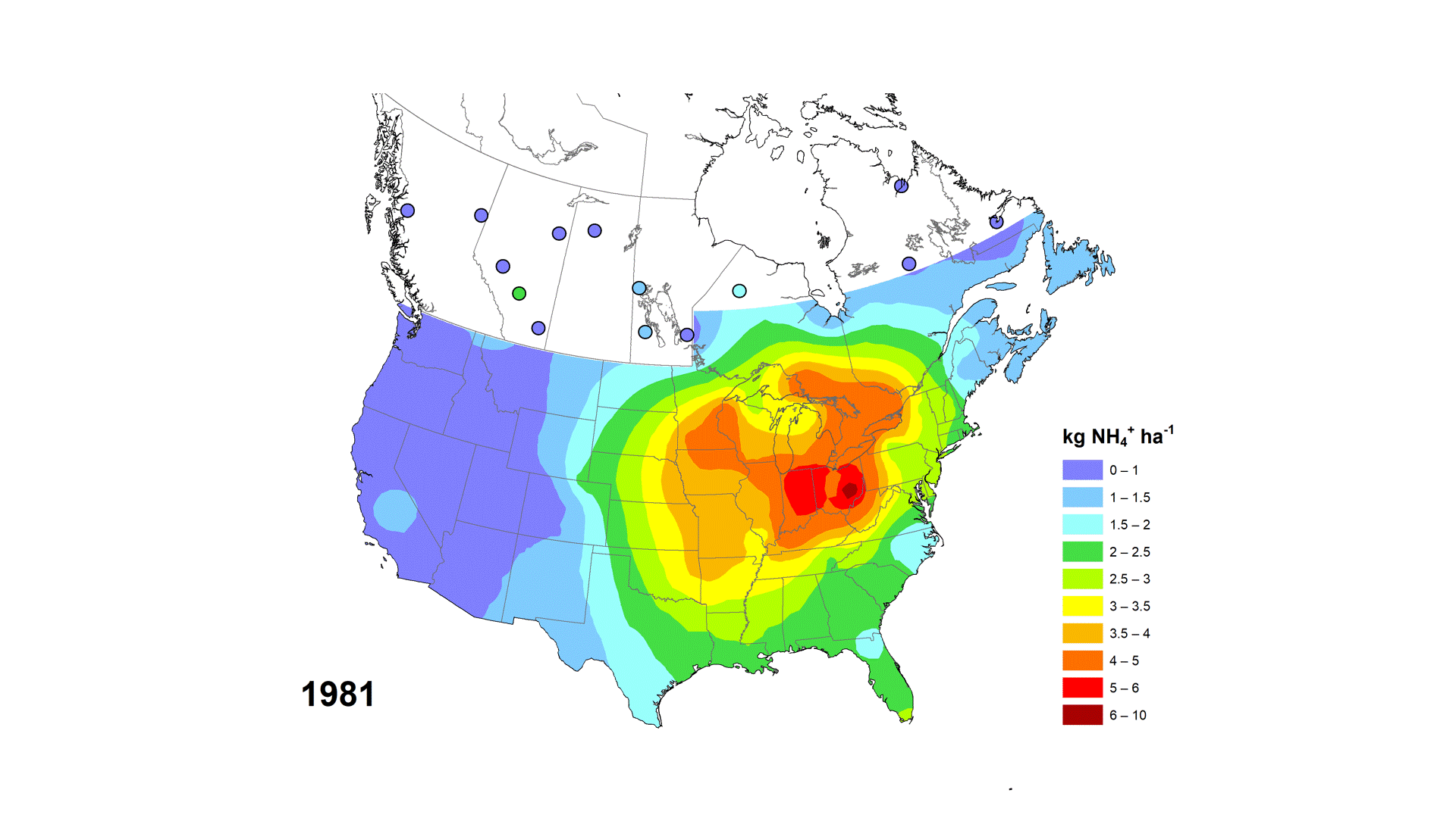
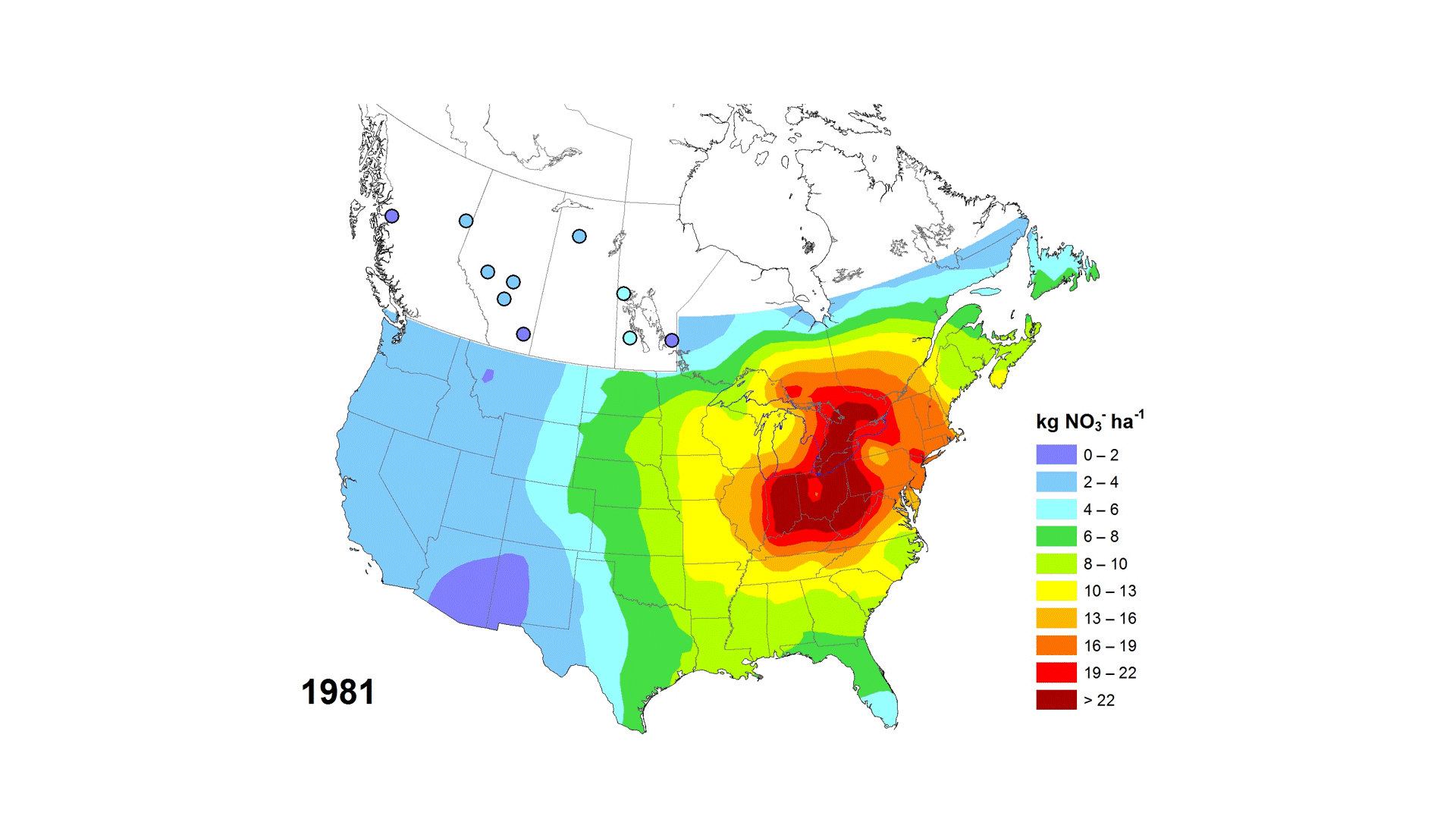
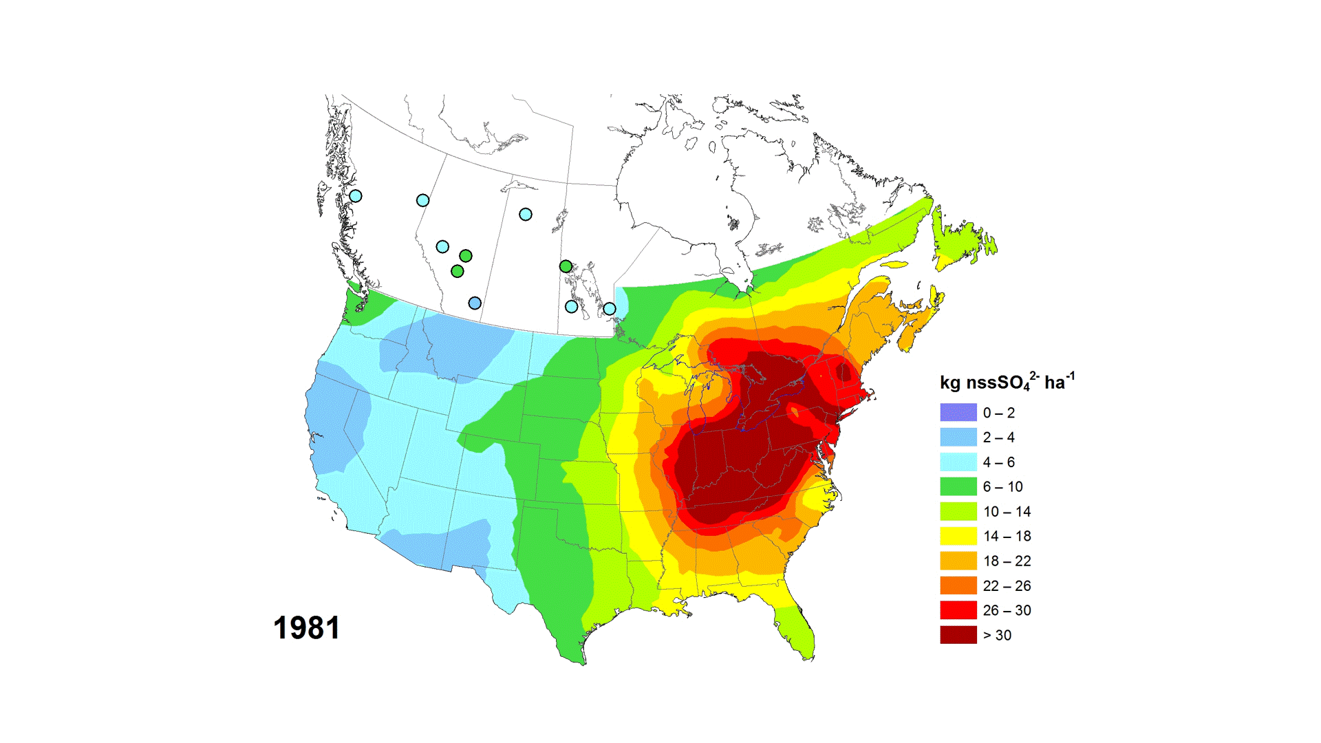
Patterns of wet deposition of the nitrate (NO3), non-sea-salt sulfate (xSO4) and ammonium (NH4) ions across areas of Canada and the United States are based on measurements of precipitation depth and ion concentrations in precipitation samples. xSO4 refers to the wet deposition of sulfate with the sea-salt sulfate contribution removed at coastal sites. These measurements were collected and quality controlled by their respective networks: in Canada, the federal Canadian Air and Precipitation Monitoring Network (CAPMoN) and provincial or territorial networks in Alberta, New Brunswick, the Northwest Territories, Nova Scotia, Ontario and Quebec. In the United States, wet deposition measurements were made by two coordinated networks: the National Atmospheric Deposition Program (NADP) / National Trends Network (NTN) and the NADP/Atmospheric Integrated Research Monitoring Network (AIRMoN). Only data from sites that were designated as regionally representative were used in the mapping. Wet deposition amounts were interpolated by ordinary kriging using ArcMap Geostatistical Analyst. The map is limited to the contiguous U.S. and southeastern or southern Canada because outside that region, the interpolation error exceeds 30% due to the larger distances between stations. Links to annual and five-year average maps are available in the associated resources.
Basic view
Metadata Record Information
- File Identifier
- e8896575-1fb8-4e53-8acd-8579c3c055c2 XML
- Date Stamp
- 2024-03-27T19:34:50
- Metadata language
-
eng; CAN
- Character set
- UTF8
- Hierarchy Level
- Dataset
Data identification
- Title
-
Wet Deposition Maps
- Date (Publication)
- 2020-03-09
- Date (Creation)
- 2019-06-13
- Status
- On going
- Metadata language
-
eng; CAN
- Character set
- UTF8
- Topic category
-
- Environment
- Maintenance and Update Frequency
- As needed
- Spatial representation type
- Vector
Keywords
- Theme
-
-
Air Quality, Atmospheric Monitoring, Atmospheric Precipitation Chemistry, Wet Deposition, NO3, Nitrate, SO4, Sulfate, Sulphate, NH4, ammonium, nitrogen, sulfur, sulphur, monitoring, atmospheric deposition, CAPMoN, Map, Kriging, Interpolate, Trend, Data product.
-
Atmosphere
-
-
Government of Canada Core Subject Thesaurus
-
-
Air quality
-
-
Business Functions
-
-
Provide Air Quality/UV Information Products and Services
-
Monitor Air Quality and UV Parameters and Manage Data
-
- Use Limitation
-
Open Government Licence - Canada ( http://open.canada.ca/en/open-government-licence-canada)
- Access Constraints
- License
- Use Constraints
- License
- Begin Date
- 1981-01-01
Extent
))
Ref. system Reference Systems
- Reference system identifier
- http://www.epsg-registry.org / EPSG:3978 /
Distribution
Distribution Formats
- Distribution format
-
- ESRI REST ( Unknown)
- WMS ( unknown)
Overviews
)))
Provided by
