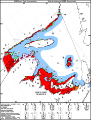
Image Analysis Ice Charts
The Canadian Ice Service acquires Synthetic Aperture Radar Satellite imagery in order to have data available for the provision of ice information. Upon request of specific clients, Synthetic Aperture Radar imagery will be analysed in more detail than for the daily ice charts and these image analysis usually available to the public. The area covered by the image analysis coincides with an area related to the satellite path. The path of the satellite changes each day so the chart area shifts from one day to the next. The usual width of the satellite data collection for ice information is about 500 kilometres. At the Canadian Ice Service, we use 100 metre resolution.
When analysing the satellite imagery, the analyst takes into consideration other data such as optical satellite imagery and visual observations from ship and aircraft. The analysis of these images is particularly challenging in conditions such as when seas are rough or if water is on the ice either from melt or rainfall.
Ice conditions are described using the International Standard Ice Code. The code describes the ice in terms of total and partial concentrations, the stages of development and form of the four main ice types present.
Basic view
Metadata Record Information
- File Identifier
- dddd7529-ca5f-440f-91ae-2092df86b361 XML
- Date Stamp
- 2021-05-12T05:53:26
- Metadata language
-
eng; CAN
- Character set
- UTF8
- Hierarchy Level
- Dataset
http://ec.gc.ca
Data identification
- Date (Revision)
- 2014-02-26
- Date (Publication)
- 2014-02-26
- Date (Creation)
- 2014-02-26
- Status
- On going
- Metadata language
-
eng; CAN
- Character set
- UTF8
- Topic category
-
- Climatology, meteorology, atmosphere
- Maintenance and Update Frequency
- Monthly
- Spatial representation type
- Vector
Keywords
- Theme
-
-
ice charts, ice, sea ice, Canadian Ice Service, Observation/Measurement
-
-
Government of Canada Core Subject Thesaurus
-
-
Ice
-
-
ECCC Information Category EN
-
-
Weather and Climate
-
-
Geography
-
-
National (CA)
-
-
Business Functions
-
-
Provide Ice Conditions Products and Services
-
Deliver Ice Conditions Products and Service to Clients
-
-
external.theme.EC_Branch
-
-
Meteorological Service of Canada
-
-
external.theme.EC_Directorate
-
-
Weather and Environmental Prediction and Services
-
-
external.theme.GC_Security_Level
-
-
Unclassified
-
- Use Limitation
-
Open Government Licence - Canada ( http://open.canada.ca/en/open-government-licence-canada )
- Access Constraints
- License
- Access Constraints
- License
- Use Constraints
- License
- Begin Date
- 2014-01-01
Extent
))
Ref. system Reference Systems
- Reference system identifier
- EPSG / 4326 /
Distribution
Distribution Formats
- Distribution format
-
-
ZIP
(
unknown
)
-
ZIP
(
unknown
)
http://ec.gc.ca
Overviews

Provided by