Shoreline mapping vector data in regions along Canada's west coast, based on low-altitude helicopter videography in support of environmental emergency preparedness efforts
With the changing climate conditions, marine traffic along Canada’s coastal regions has increased over the past couple of decades and the need to improve our state of preparedness for oil-spill-related emergencies is critical. Baseline coastal information, such as shoreline form, substrate, and vegetation type, is required for prioritizing operations, coordinating onsite spill response activities (i.e. Shoreline Cleanup Assessment Technique [SCAT]), and providing information for wildlife and ecosystem management.
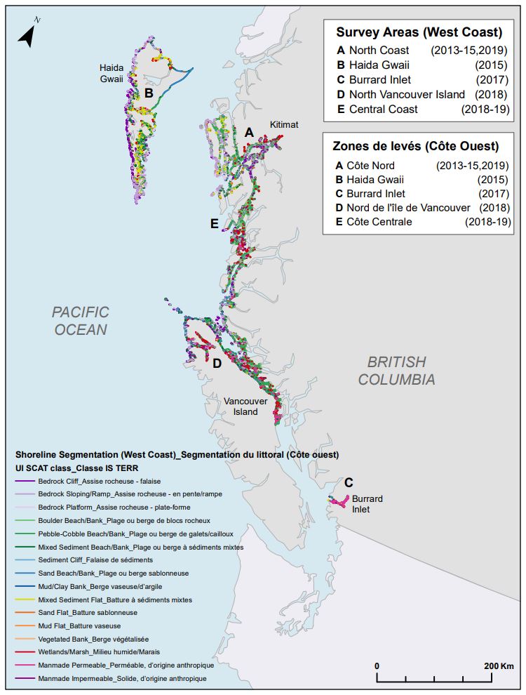
Between 2013 and 2019, georeferenced high-definition videography and photos were collected for various study sites along the west coast. The study areas include the mainland, inlets, channels and islands along the BC coast starting from Kitimat in the north to Quadra Island in the south, including Haida Gwaii and North Vancouver Island in the west and Burrard Inlet in the extreme south.
Data was collected during low tide conditions (where applicable) between July and September. Low-altitude helicopter surveys were conducted at each of the study site to capture video of the shoreline characteristics. In addition to acquiring videography, ground-based observations were recorded in several locations for validation.
Shoreline segmentation was then carried out by manual interpretation of the oblique videography and the photos aided by ancillary data. This involved splitting and classifying the shoreline vectors based on homogeneity of the upper intertidal zone. Detailed geomorphological information (i.e. shoreline type, substrate, slope, height, accessibility etc.) describing the upper intertidal, lower intertidal, supratidal and backshore zones was extracted from the video and entered into a geospatial database using a customized data collection form. In addition, biological characteristics like biobands, water features, fauna, human use etc. observed along the coast were recorded.
The data was also validated through ground samples (when available) and a second interpreter QA (quality analysis) was performed on the dataset to ensure high quality and consistency.
The final dataset contains segments ranging in length from 150 metres (45 metres for study areas surveyed in 2018-19) to 2500 metres. In total, from 2013 to 2019, about 15,000 km of shoreline were segmented.
Basic view
Metadata Record Information
- File Identifier
- a78f026c-d998-46db-aecc-a488f247fb63 XML
- Date Stamp
- 2022-10-13T13:20:14
- Metadata language
-
eng; CAN
- Character set
- UTF8
- Hierarchy Level
- Dataset
819-994-1412
https://www.canada.ca/en/environment-climate-change.html
Data identification
- Title
-
Shoreline mapping vector data in regions along Canada's west coast, based on low-altitude helicopter videography in support of environmental emergency preparedness efforts
- Date (Publication)
- 2020-08-15
- Date (Creation)
- 2020-08-13
- Status
- On going
- Metadata language
-
eng; CAN
- Topic category
-
- Environment
- Maintenance and Update Frequency
- Irregular
- Spatial representation type
- Vector
Keywords
- Theme
-
-
Canadian Pacific, shorelines, oil spill, emergency preparedness, sensitivity mapping, shoreline segmentation, videography, Kitimat, Haida Gwaii, Burrard Inlet, Vancouver Island, coastal management, coastal studies
-
-
Government of Canada Core Subject Thesaurus
-
-
Environmental emergencies
-
Environmental protection
-
-
Business Functions
-
-
Assess Status of Species
-
Protect Species Well-Being
-
- Use Limitation
-
Open Government Licence - Canada ( http://open.canada.ca/en/open-government-licence-canada)
- Access Constraints
- License
- Use Constraints
- License
- Begin Date
- 2010-06-01
- End Date
- 2017-09-01
Extent
))
Ref. system Reference Systems
- Reference system identifier
- http://www.epsg-registry.org / EPSG:3978 /
Distribution
Distribution Formats
- Distribution format
-
- CSV ( unknown)
https://www.canada.ca/en/environment-climate-change.html
Overviews
)))
Provided by
