Canadian Water Resources Vulnerability Index - Permafrost Loss
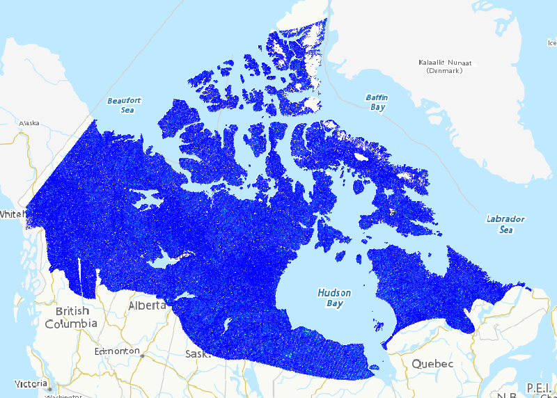
Permafrost loss is pervasive across northern circumpolar regions. The loss of frozen ground has profound impacts on water resources at varying spatial and temporal scales via changes to predominant hydrological processes, runoff pathways and entrainment rates of solutes and sediments. Consensus exists that permafrost loss will continue, and rates will vary spatially, but how hydrology and biogeochemistry will respond across large swaths of land remains largely unknown. Previous research elucidated small-scale processes or described circumpolar trends, with minimal cross-scale research. In particular, a pan-Canadian assessment of water resource vulnerability to permafrost loss is lacking. This study develops and applies a framework for assessing vulnerability of pan-Canadian water resources to permafrost loss. For the purposes of this study, “water resources” is defined as the surface hydrological and aquatic chemistry regime characterized by water budgets, aquatic chemistry concentrations and loads. The framework was applied in developing the Canadian Water Resources Vulnerability Index to Permafrost Loss (CWRVIPL), including mapping of the index across the Canadian North. The CWRVIPL is a linearly additive index of permafrost, physiographic, disturbance and climatic conditions and stressors that influence water budgets and aquatic chemistry. Initial results imply aspects of water resources in northern Alberta, the Northwest Territories and the Hudson Bay Lowlands are most vulnerable to permafrost loss, and these regions are embedded in a large band of relatively more vulnerable territory extending from the northern Yukon south to James Bay and northeastward to Labrador. In the Arctic Archipelago, water resources in portions of Banks, Victoria and Baffin Islands are also relatively vulnerable to permafrost loss. The index identifies areas of water resource vulnerability on which to focus and encourage ongoing observation and research in the Canadian North.
Basic view
Metadata Record Information
- File Identifier
- 70bbb27a-53e8-4259-bb0a-7688b5e954f5 XML
- Date Stamp
- 2023-03-21T19:57:28
- Metadata language
-
eng; CAN
- Character set
- UTF8
- Hierarchy Level
- Dataset
https://www.canada.ca/en/environment-climate-change.html
Data identification
- Date (Creation)
- 2019-09-01
- Date (Publication)
- 2019-09-30
- Status
- Completed
- Metadata language
-
eng; CAN
- Character set
- UTF8
- Topic category
-
- Inland waters
- Maintenance and Update Frequency
- Not planned
- Spatial representation type
- Vector
Keywords
- Theme
-
-
Environmental Model
-
Permafrost, Water Quantity, Streamflow, Water Chemistry, Vulnerability, Yukon, Northwest Territories, Nunavut
-
-
ECCC Information Category EN
-
-
Water
-
-
Business Functions
-
-
Expand Scientific Knowledge for Climate Monitoring and Prediction
-
Provide Climate Information Products and Services
-
-
Government of Canada Core Subject Thesaurus
-
-
Water
-
-
Geography
-
-
National (CA)
-
-
external.theme.EC_Directorate
-
-
Water Science and Technology
-
-
external.theme.EC_Branch
-
-
Science and Technology Branch
-
-
external.theme.GC_Security_Level
-
-
Unclassified
-
- Use Limitation
-
Open Government Licence - Canada ( http://open.canada.ca/en/open-government-licence-canada )
- Access Constraints
- License
- Use Constraints
- License
- Begin Date
- 2019-08-19
Extent
))
Ref. system Reference Systems
- Reference system identifier
- http://www.epsg-registry.org / EPSG:3978 /
Distribution
Distribution Formats
- Distribution format
-
-
CSV
(
unknown
)
-
CSV
(
unknown
)
http://ec.gc.ca
Overviews
Provided by