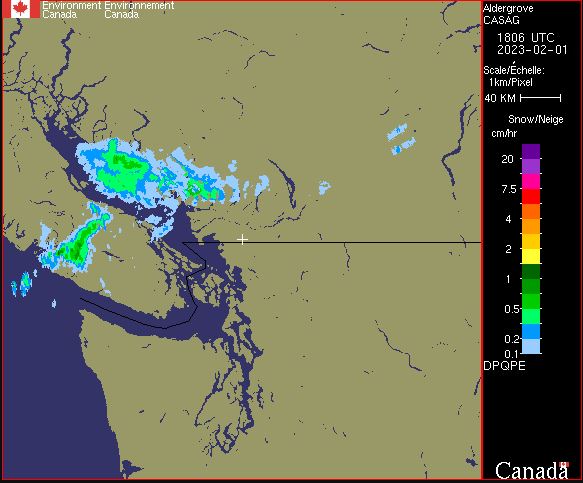
Weather Radar - DPQPE
DPQPE product: DPQPE stands for: Dual Polarization Quantitative Precipitation Estimation. The DPQPE product is available only for S-Band radars. It is a two-dimensional representation of the precipitation rate estimated by the lowest sweep of the radar (elevation angle of 0.4 degrees for the majority of S-Band radars). Thus, the precipitation rate is estimated as close to the earth's surface as possible. The DPQPE product is based, among other things, on a series of polarimetric processing steps (quality control) to eliminate non-meteorological artifacts from the raw data (volumetric scans). It renders in mm/h for rain and cm/h for snow. This product is calculated with a maximum coverage range of 240 km.
Basic view
Metadata Record Information
- File Identifier
- 6059da1d-e1da-4f2b-a420-b5c2a130eeaa XML
- Date Stamp
- 2024-03-28T14:58:04
- Metadata language
-
eng; CAN
- Character set
- UTF8
- Hierarchy Level
- Dataset
+01-506-451-6010
Data identification
- Date (Publication)
- 2023-02-03
- Date (Creation)
- 1871-01-01
- Status
- On going
- Metadata language
-
eng; CAN
- Character set
- utf8
- Topic category
-
- Climatology, meteorology, atmosphere
- Maintenance and Update Frequency
- Continual
- Spatial representation type
- Grid
+01-506-451-6010
Keywords
- Theme
-
-
Atmospheric conditions
-
Meteorology
-
Weather
-
-
Government of Canada Core Subject Thesaurus
-
-
Radar
-
Remote sensing
-
Weather
-
-
Business Functions
-
-
Provide Weather Information Products and Services
-
Deliver Weather Products and Services to Clients
-
-
Branch
-
-
Meteorological Service of Canada
-
-
Directorate
-
-
Weather and Environmental Operations
-
-
GC Security Level
-
-
Unclassified
-
-
Geography
-
-
National (CA)
-
- Use Limitation
-
Open Government Licence - Canada ( http://open.canada.ca/en/open-government-licence-canada )
- Access Constraints
- Other restrictions
- Use Constraints
- Other restrictions
- Begin Date
- 1871-01-01
Extent
))
Ref. system Reference Systems
- Reference system identifier
- http://www.epsg-registry.org / EPSG:4326 /
Distribution
Distribution Formats
- Distribution format
-
-
GIF
(
89a
)
-
GIF
(
89a
)
+01-506-451-6010
Overviews
Provided by