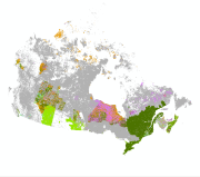
Canadian Wetlands
The national wetland layer contains wetland data compiled from the best available data from each region, classified by wetland type. Wetlands are mapped as polygons in geographic layers, which are integrated into a master geodatabase at the national scale.Information from each contributing dataset was classified based on the Canadian Wetland Classification System, which contains five main wetland classes (Bog, Fen, Marsh, Swamp, and Shallow Water) that represent the types of wetlands encountered in Canada. An additional category, “partially classified” was used to preserve boundary information for wetlands that could not be classified into the main categories with existing information.
Basic view
Metadata Record Information
- File Identifier
- 5095a5e0-e574-4769-84d3-acaac529399b XML
- Date Stamp
- 2025-04-01T20:22:28.835Z
- Metadata language
-
eng; CAN
- Character set
- UTF8
- Hierarchy Level
- Series
819-953-7177
Data identification
- Title
-
Canadian Wetlands
- Date (Creation)
- 2013-12-02
- Date (Publication)
- 2013-12-06
- Status
- On going
- Metadata language
-
eng; CAN
- Character set
- UTF8
- Topic category
-
- Biota
- Maintenance and Update Frequency
- Annually
- Spatial representation type
- Vector
819-953-7177
Keywords
- Place
-
-
Canada
-
- Theme
-
-
wetlands, bog, fen, marsh, swamp, shallow water
-
Geographic Feature
-
-
ECCC Information Category EN
-
-
Other
-
-
Government of Canada Core Subject Thesaurus
-
-
Wetlands
-
-
Business Functions
-
-
Protect Species Well-Being
-
Information Systems for Species
-
-
Geography
-
-
National (CA)
-
-
external.theme.EC_Branch
-
-
Environmental Stewardship Branch
-
Environmental Stewardship Branch
-
Environmental Stewardship Branch
-
-
external.theme.EC_Directorate
-
-
Canadian Wildlife Service
-
Canadian Wildlife Service
-
Canadian Wildlife Service
-
-
external.theme.GC_Security_Level
-
-
Unclassified
-
Unclassified
-
Unclassified
-
- Access Constraints
- Copyright
- Use Constraints
- Copyright
- Security Classification
- Unclassified
- Use Limitation
-
Open Government Licence - Canada ( http://open.canada.ca/en/open-government-licence-canada)
- Access Constraints
- License
- Use Constraints
- Copyright
- Begin Date
- 2011-04-01
- End Date
- 2013-03-29
Extent
))
Ref. system Reference Systems
- Reference system identifier
- EPSG / EPSG:4617 / 7.11.2
- Topology level
- Geometry only
- Geometric object type
- Composite
- Geometric object count
- 11504772
Distribution
Distribution Formats
- Distribution format
-
- FGDB/GDB ( unknown)
- ESRI REST ( unknown)
- WMS ( unknown)
http://ec.gc.ca
Overviews


)))
Provided by
