NH4 Wet Deposition Maps
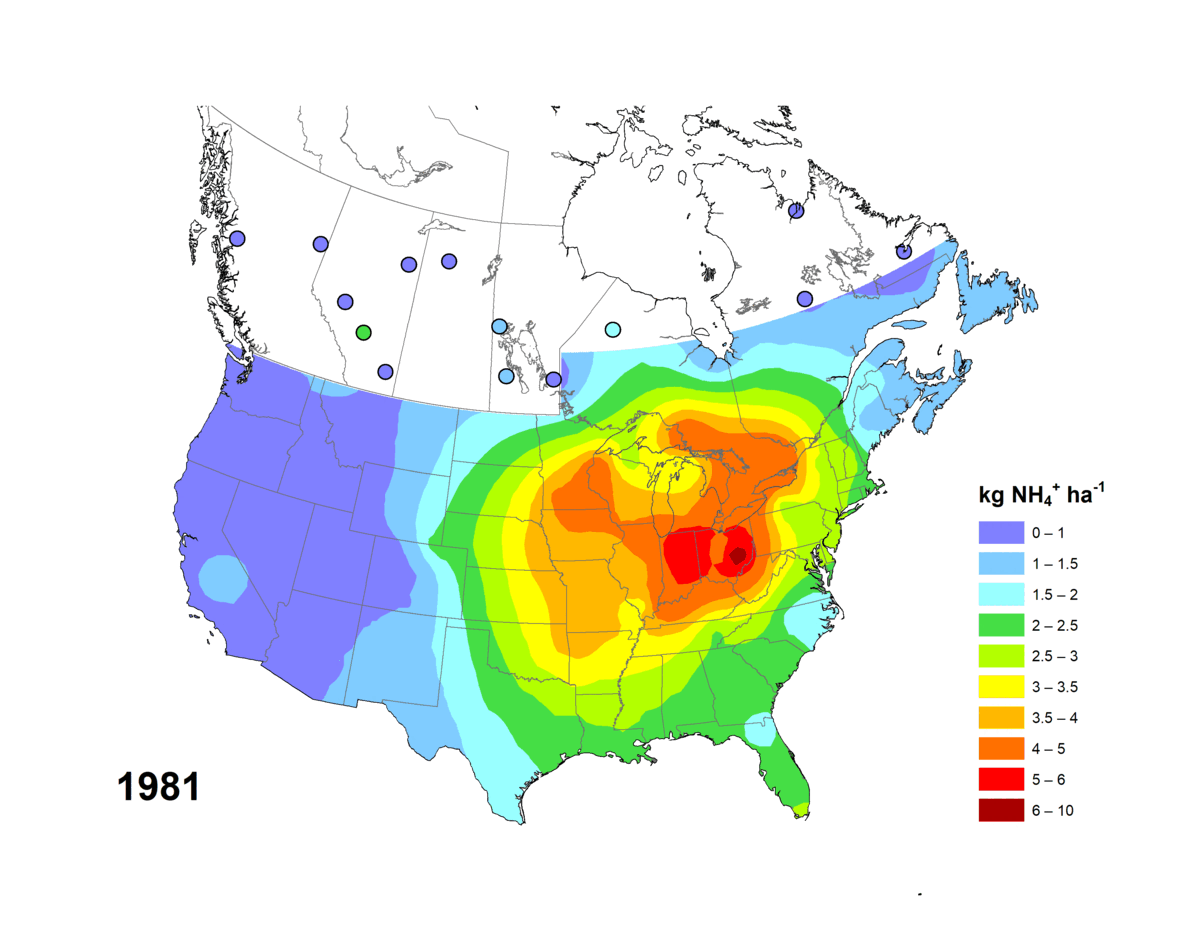
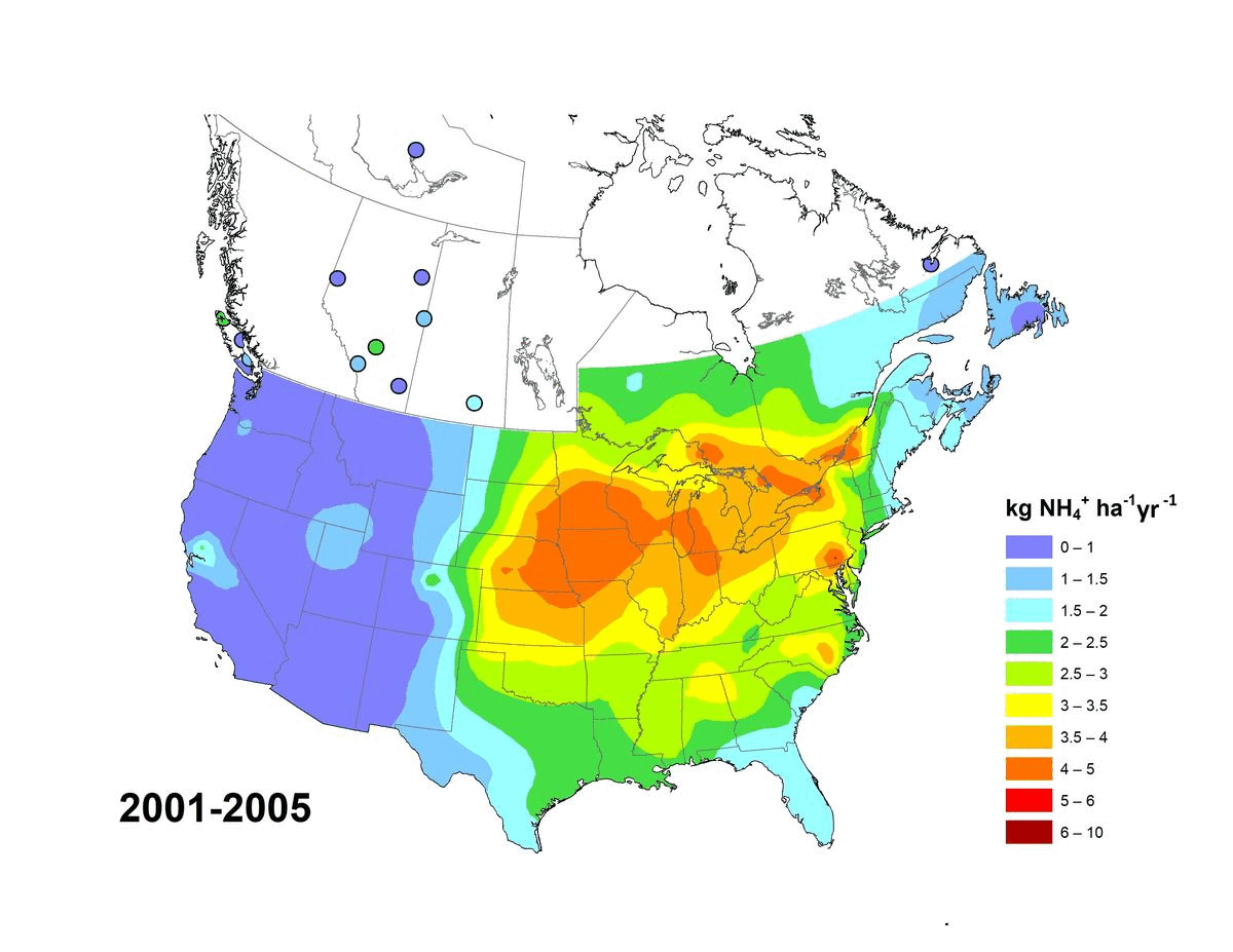
Annual and five-year (5YA) average wet deposition maps for the ammonium ion are available. The file formats include geodatabase files (*.gdb) compatible with geospatial software (e.g. ESRI ArcGIS) and KMZ files compatible with virtual globe software (e.g. Google Earth™). Maps can also be viewed online via Open Maps and the ArcGIS online viewer. Annual deposition from each site was screened for completeness using the following criteria: (1) precipitation amounts were recorded for >90% of the year and >60% of each quarter, and (2) ammonium concentrations were reported for >70% of the precipitation measured over the year and for >60% of each quarter. Five-year average wet deposition values are averaged annual deposition values with a completeness criterion >60% for the five-year period. Units for wet deposition fluxes are in kg of NH4 per hectare per year (kg ha-1 y-1). Sources of measurement data and spatial interpolation method are described here: https://doi.org/10.18164/e8896575-1fb8-4e53-8acd-8579c3c055c 2.
Recommended citation: Environment and Climate Change Canada, [year published]. NH4 Wet Deposition Maps. Air Quality Research Division, Environment and Climate Change Canada, Toronto, Ontario, Canada. [URL/DOI], accessed [date].
Recommended acknowledgement: The author(s) acknowledge Environment and Climate Change Canada for the provision of Canada-U.S. wet deposition kriging maps accessed from the Government of Canada Open Government Portal at open.canada.ca, and the data providers referenced therein.
Basic view
Metadata Record Information
- File Identifier
- f83fb6c8-fff0-4c49-8c14-968dd8b569bc XML
- Date Stamp
- 2024-01-19T19:15:45
- Metadata language
-
eng; CAN
- Character set
- UTF8
- Hierarchy Level
- Dataset
Data identification
- Date (Publication)
- 2023-11-30
- Date (Creation)
- 2023-08-09
- Status
- On going
- Metadata language
-
eng; CAN
- Character set
- UTF8
- Topic category
-
- Environment
- Maintenance and Update Frequency
- As needed
- Spatial representation type
- Vector
Keywords
- Theme
-
-
Air Quality, Atmospheric Monitoring, Atmospheric Precipitation Chemistry, Wet Deposition, NO3, Nitrate, SO4, Sulfate, Sulphate, NH4, ammonium, nitrogen, sulfur, sulphur, monitoring, atmospheric deposition, CAPMoN, Map, Kriging, Interpolate, Trend, Data product.
-
Atmosphere
-
-
Government of Canada Core Subject Thesaurus
-
-
Air quality
-
-
Business Functions
-
-
Provide Air Quality/UV Information Products and Services
-
Monitor Air Quality and UV Parameters and Manage Data
-
- Use Limitation
-
Open Government Licence - Canada ( http://open.canada.ca/en/open-government-licence-canada )
- Access Constraints
- License
- Use Constraints
- License
- Begin Date
- 1981-01-01
Extent
))
Ref. system Reference Systems
- Reference system identifier
- http://www.epsg-registry.org / EPSG:3978 /
Distribution
Distribution Formats
- Distribution format
-
-
ESRI REST
(
Unknown
)
-
WMS
(
unknown
)
-
ESRI REST
(
Unknown
)
Overviews
Provided by