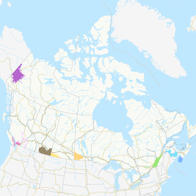
Priority Places for Species at Risk (Terrestrial): Boundaries
A Priority Place is an area of high biodiversity value that is seen as a distinct place with a common ecological theme by the people who live and work there. As part of the Pan-Canadian approach to transforming Species at Risk conservation in Canada, a total of 11 Priority Places were affirmed by federal, provincial, and territorial governments in December 2018. The places selected have significant biodiversity, concentrations of species at risk, and opportunities to advance conservation efforts. In each Priority Place, the federal and provincial or territorial governments are working with Indigenous Peoples, partners, and stakeholders to develop conservation implementation plans. This dataset displays the geographic area covered by each of the 11 Priority Places using the best available information from the Canadian Wildlife Service (CWS). Boundary information for each Priority Place was provided by its respective CWS regional office.
The federal government, in collaboration with the provinces and territories, has agreed to the implementation of the Pan-Canadian Approach to Transforming Species at Risk Conservation in Canada. This new approach shifts from a single-species approach to conservation to one that focuses on multiple species and ecosystems. This enables conservation partners to work together to achieve better outcomes for species at risk. These 11 Priority Places are complemented by a suite of Community-Nominated Priority Places (CNPP), identified through an open call for applications.
Basic view
Metadata Record Information
- File Identifier
- bdb8ba6a-9c0a-47ed-971d-5eefa8fe977f XML
- Date Stamp
- 2023-10-06T14:47:25
- Metadata language
-
eng; CAN
- Character set
- UTF8
- Hierarchy Level
- Dataset
Data identification
- Date (Creation)
- 2018-12-31
- Date (Publication)
- 2022-03-10
- Date (Revision)
- 2023-11-01
- Status
- Completed
- Metadata language
-
eng; CAN, fr; CAN
- Character set
- utf8
- Topic category
-
- Environment
- Biota
- Boundaries
- Maintenance and Update Frequency
- As needed
- Spatial representation type
- Vector
Keywords
- Discipline
-
-
Priority Place
-
Pan-Canadian approach
-
Species at Risk
-
Migratory Birds
-
Biodiversity
-
Canada Nature Fund
-
Conservation Action Plan
-
- Place
-
-
Kespukwitk / Southwest Nova Scotia
-
Wolastok / Saint John River
-
PEI Forested Landscape
-
St Lawrence Lowlands
-
Long Point Walsingham Forest
-
Southwest Manitoba
-
South of the Divide
-
Summit to Sage
-
Dry Interior British Columbia
-
Southwest British Columbia
-
Yukon South Beringia
-
-
Government of Canada Core Subject Thesaurus
-
-
Environment
-
Boundaries
-
Endangered species
-
-
Business Functions
-
-
Protect Species Well-Being
-
Plans and Reports for Species
-
- Use Limitation
-
Open Government Licence - Canada ( http://open.canada.ca/en/open-government-licence-canada )
- Access Constraints
- License
- Use Constraints
- License
- Begin Date
- 2018-12-31
Extent
))
Ref. system Reference Systems
- Reference system identifier
- http://www.epsg-registry.org / EPSG:3978 /
Distribution
Distribution Formats
- Distribution format
-
-
FGDB/GDB
(
1
)
-
FGDB/GDB
(
1
)
Overviews
Provided by